
The Lake Powell Boating Map: GPS Tracks, Waypoints & Hazards
The live satellite map boaters have been asking for — record your tracks, drop waypoints on the spots you love, see the hazards the fleet flags, and take the whole lake with you, offline, up every canyon.
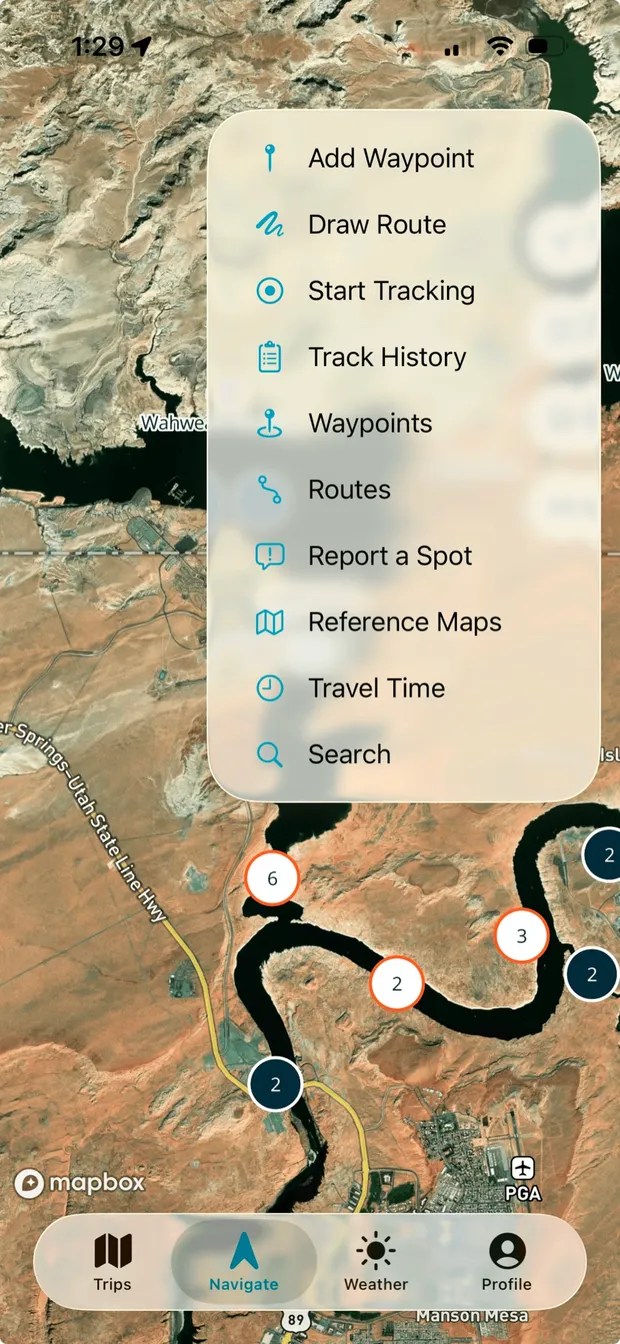
Ten tools, one tap from the map
Everything the map can do lives in one quick menu, right on the map — no digging through settings screens with wet hands. Each tool gets its own deep dive below.
- Add Waypoint — pin the spot you’re floating over before you forget it.
- Draw Route — sketch tomorrow’s run right on the canyons.
- Start Tracking — one tap and your wake starts drawing behind you.
- Track History — every past run, saved and replayable.
- Waypoints — your whole library of saved spots in one list.
- Routes — saved routes, ready to follow again.
- Report a Spot — flag a hazard or a find for the rest of the fleet.
- Reference Maps — the classic printable maps, along for the ride.
- Travel Time — miles and minutes between any two points on the lake.
- Search — jump to any canyon, bay, or marina by name.
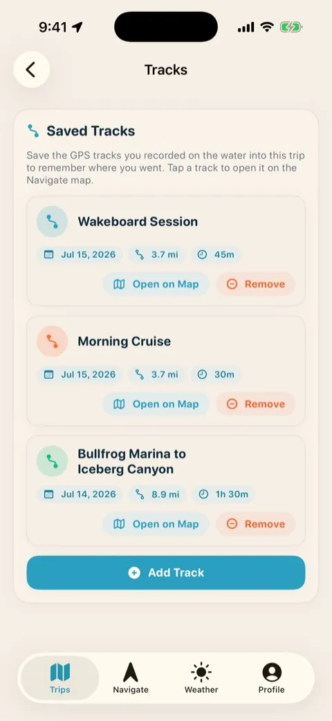
See exactly where your boat went
Turn on tracking when you leave the marina and the map records every run on the water. Your track draws live as a breadcrumb trail behind the boat, so you always know the line you took — and you can look back at where you actually went, not where you meant to go.
- Live breadcrumb trail — your path draws behind you in real time as you run.
- Look back at the day — replay the exact route you took to a cove or fishing hole.
- Saved to the trip — every track is kept with the trip so the whole crew can see it.
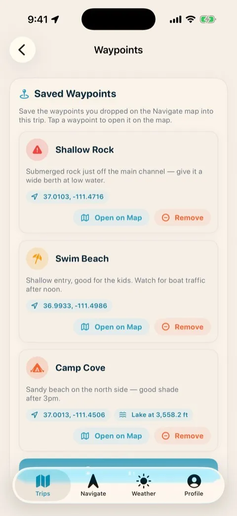
Remember where you stayed, every year
Drop a pin on the beach you camped, the cove that held glass-calm water at dawn, the spot the fish were biting. Name it, add a note, and it’s there next season — so the place you spent three summers finding is never lost again.
- Pin any spot — a beach, an anchorage, a launch, a secret cove.
- Name it and note it — add a label and details you’ll actually remember.
- Find it again — your saved places come back trip after trip, year after year.
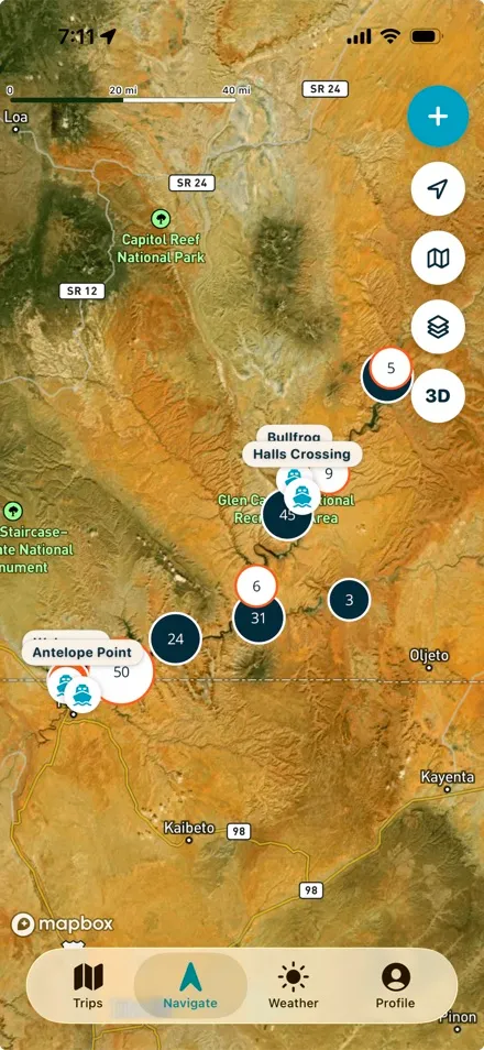
Spots and hazards shared by the fleet
Beyond your own pins, the map carries waypoints and hazard markers added by boaters out on the water — shallow spots, floating debris, and submerged-rock warnings the fleet flags for each other. It’s part of the 300+ points of interest, and it pairs well with our Lake Powell navigation hazards guide.
- Community waypoints — good beaches and anchorages other boaters have marked.
- Hazard markers — shallow water, debris, and submerged rocks flagged by the fleet.
- Always growing — part of the 300+ points of interest already on the map.
Plan the line before you launch
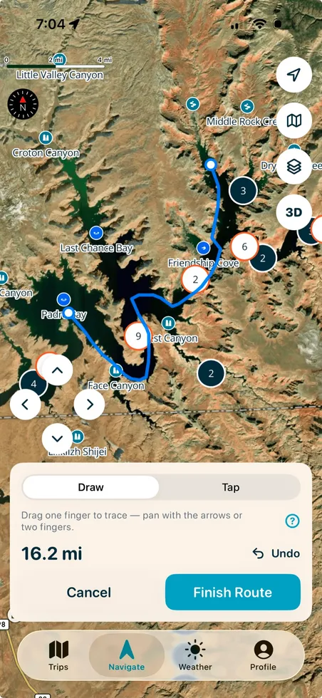
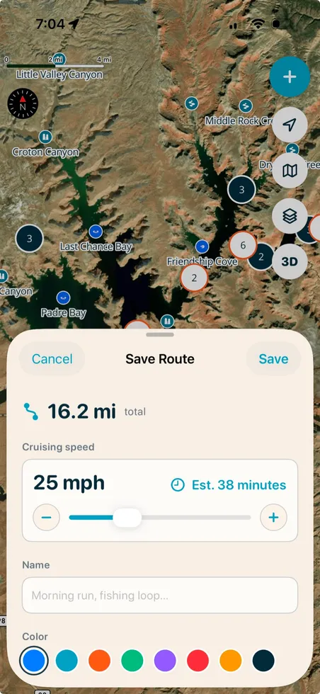
Lay out a route before you leave the ramp, follow it on the water, and know the distance between every stop, so you can budget fuel and daylight before you leave. Planning the trip around it? Our Lake Powell trip-planning guides walk through distances, fuel, and itineraries.
- Draw it or tap it — trace the line with one finger and the mileage adds up live.
- Save it with an estimate — name the route, set your cruising speed, and see the time before you commit.
- Follow it on the lake — the same route rides along in your pocket on iOS.
Know if it’s 41 minutes or 2 hours — before you go
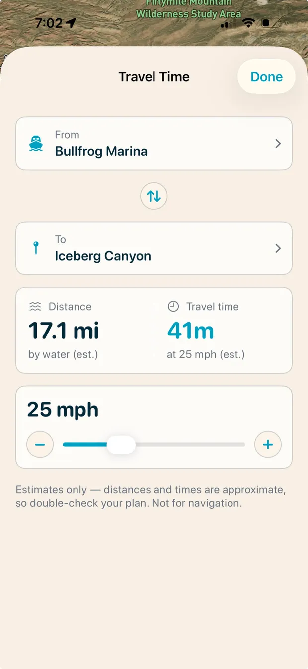
Pick any two points on the lake — marina to canyon, ramp to anchorage — and get the water distance and travel time at your cruising speed. Slide the mph to match your boat and the estimate updates instantly, so fuel, daylight, and dinner reservations all stay honest. For typical runs between marinas and canyons, see our Lake Powell distance guide.
- Marina to canyon in seconds — pick a From and a To, get miles by water and minutes underway.
- Dialed to your boat — a houseboat at 8 mph and a wakeboat at 25 mph get very different answers.
- Budget fuel and daylight — know what a run really costs before you commit to it.
A living map of the whole lake
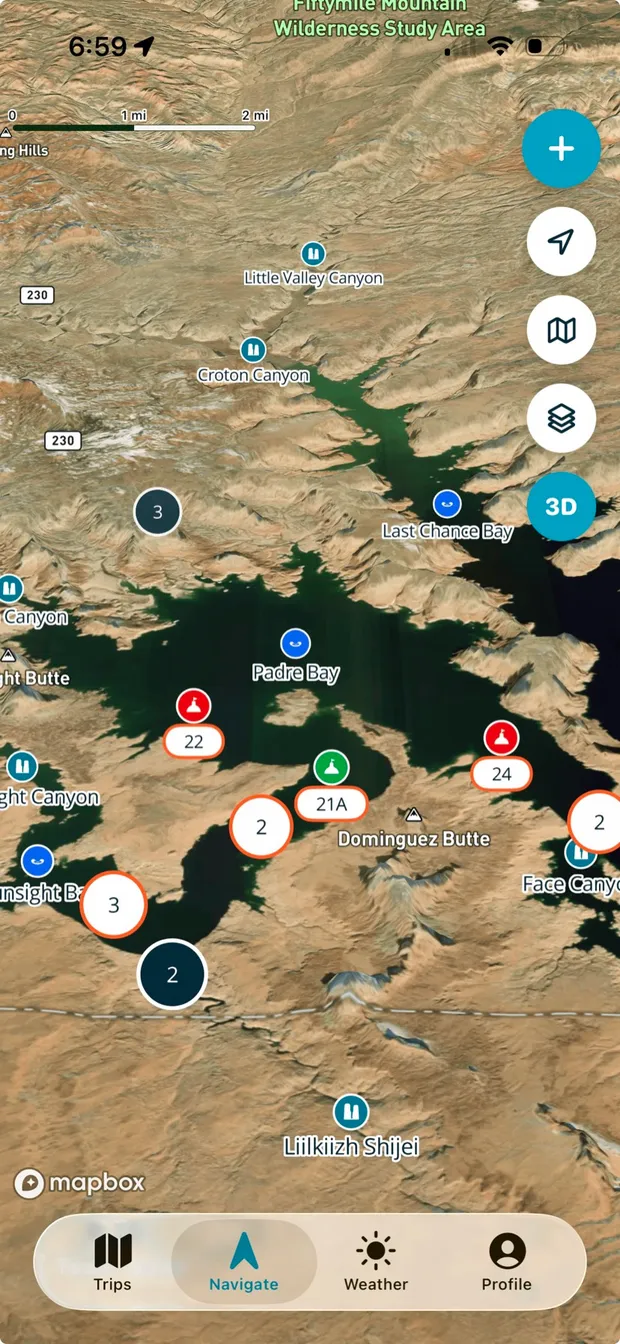
Under all of it is live satellite imagery of Lake Powell, searchable and labeled the way boaters actually talk about the lake. Every canyon, bay, arch, ramp, and marina is named and findable — not a static brochure scan, a map you can zoom, search, and flip into 3D.
- 132 named side canyons searchable by name, plus 48 sight landmarks to navigate by.
- 20 named bays and coves and 18 arches, Rainbow Bridge included.
- Every ramp and all four marinas, a buoy layer, and a 3D view of the canyon walls.
Still works 30 miles up-lake
Cell service quits long before the good canyons start. The map is built to keep working with zero bars — your position, your waypoints, and your route all stay live deep up-lake. See how the rest of the app handles the dead zone on the full feature tour.
- Zero cell service, full map — the canyons keep rendering with no signal.
- Your pins and routes stay put and stay usable off-grid.
- Built for the dead zone — where most navigation apps simply go blank.
Frequently asked questions
Can I save my own waypoints on Lake Powell?
Yes. Drop a pin on any spot — a beach, a cove, an anchorage, a fishing hole — then name it and add a note. Your saved waypoints stay on your map trip after trip, so the places you spent years finding come back every season.
Does the map show hazards?
It does. Alongside your own pins, the map carries community-shared hazard markers — shallow spots, floating debris, and submerged rocks flagged by boaters out on the water. They’re part of the 300+ points of interest layered on the map.
Does the map work offline?
Yes, on iOS. The map is built to keep working with zero cell service, so your position, waypoints, and route all stay live 30 miles up-lake where most navigation apps go blank.
Can the app estimate travel time between two points on Lake Powell?
Yes. Pick any two points — say, Bullfrog Marina to Iceberg Canyon — and the app shows the distance by water and the travel time at your cruising speed, adjustable with an mph slider. Estimates are approximate and meant for planning, not navigation.
Can I track where my boat went?
Turn on GPS tracking and the app records your run as a live breadcrumb trail. You can look back at the exact line you took, and the track is saved to the trip for everyone to see.
Put the whole lake in your pocket
Tracks, waypoints, hazards, and 300+ points of interest — on a map that still works up the last canyon. Free to try.