
Does your GPS work on Lake Powell without cell service?
Your phone’s GPS works on Lake Powell with no cell bars. The fix is offline maps and a few settings tweaks so canyon walls don’t scramble your dot.
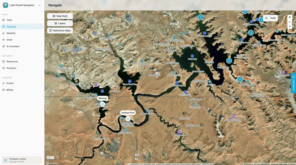
Quick answer
Yes — your phone’s GPS works on Lake Powell even with no cell bars, because the GPS chip fixes your position straight from satellites. The catch is the map itself: tiles and labels need a signal to load. Download an offline map before you leave the marina, keep the phone where it can see sky, and your blue dot works across the whole lake.
Most of Lake Powell has no cell service. Get a few miles up-lake and your phone drops to zero bars — which panics first-timers who assume the map dies with the signal. It doesn’t. Position and map are two separate things, and once you understand the split, navigating out here stops being a worry.
Here’s the whole idea in one table before the details.
| What you need | Where it comes from | Cell service needed? |
|---|---|---|
| Your position (the blue dot) | GPS/GNSS satellites, direct to your phone | No |
| The map underneath it | Cached tiles on your phone, or live download | Only to download |
| Live routing & search | Downloaded map data or a connection | Only if not pre-cached |
| Weather & conditions | A signal, or a pre-launch download | Yes, to fetch |
Do you need cell service for GPS to work?
No. This is the single most useful thing to know before you launch. The GPS chip in your phone is a receiver — it listens for timing signals from satellites and works out where you are from them. That has nothing to do with your carrier. You could be in airplane mode with the SIM pulled and the blue dot would still track you up the lake.
What actually needs a connection is the map picture: the shoreline, the labels, the points of interest. If those tiles aren’t already saved on your phone, the app tries to fetch them over data — and with no bars, you get a gray screen with a blue dot floating on nothing. The fix is to cache the map while you still have a signal at the marina. Do that and you carry the whole lake in your pocket.
Modern phones aren’t even relying on the U.S. GPS network alone. They pull from several satellite systems at once — GLONASS, Galileo and BeiDou alongside GPS — under the umbrella name GNSS. More satellites in view means a faster, tighter fix, which is exactly what you want when canyon walls are already eating half the sky.
Why does GPS drift near canyon walls?
Lake Powell is a maze of narrow, high-walled side canyons, and those walls are hard on satellite signals. It’s the same problem as a downtown full of skyscrapers, just carved in sandstone: signals get blocked on one side and bounce off the rock on the other, arriving a fraction late. Your phone can’t tell a bounced signal from a clean one, so the position jumps, lags, or freezes for a moment.
When the satellite fix gets shaky, the phone leans on its other sensors — compass, accelerometer, gyroscope — to fill the gaps. If the compass is off, your heading points the wrong way even when your dot is roughly right. Two things settle it down: recalibrate the compass (open the map app, tap your blue dot, choose calibrate, and swing the phone in a figure-eight), and keep the phone mounted up high with a clear view of the sky rather than face-down in a cup holder.
This is also why a route that looked fine on the main channel gets twitchy once you nose into a slot canyon. It’s normal. Slow down, trust the general direction over the exact pixel, and watch the shoreline against your known hazards and no-wake zones rather than the dot alone.
How do you set up offline maps before you launch?
Cache the map at the marina, while you still have bars. Every serious navigation app can save a region for offline use; the steps are nearly identical.
- Open the app on Wi-Fi or cell service at the marina.
- Find the offline maps or download option in the menu.
- Select the Lake Powell area — drag the box to cover the arms you plan to explore, not just the main channel.
- Download, and confirm it finished before you leave signal.
- Test it: turn on airplane mode for a moment and pan the map. If it still draws, you’re set.
Pull a wider area than you think you need. It’s free storage, and the day you decide to run up a side canyon you didn’t plan for is the day you’ll want it. Refresh the download every couple of months so ramp access roads and closures stay current.
One more habit worth building: download the weather forecast and mark your fuel stops before you go, too. Services on this lake are spread across a handful of marinas, so knowing where the next open fuel dock sits matters as much as the map — see the marina guides and plan the legs with the distance guide.
How do you fix a wrong or frozen position?
If the blue dot is off by a block, stuck in place, or pointing the wrong way, work through these in order. Most on-water GPS gripes clear up in under a minute.
- Reset location. Toggle Location Services off for ten seconds, then back on. It forces a fresh fix.
- Turn on high-accuracy mode (Android: Settings → Location → Google Location Accuracy). It ropes in extra sensors for a tighter lock.
- Recalibrate the compass with the figure-eight motion if your heading is wrong on turns.
- Mount it high. A phone with a clear view of the sky fixes faster than one buried in a bag.
- Check the app is current. An outdated app can carry stale map data or a fixed bug.
- Keep it charged. A phone throttling itself to save a dying battery will skimp on GPS precision exactly when you need it.
Which navigation app or device should you use?
There’s no single best answer — it depends on how you boat. Here’s the honest breakdown.
| Use case | Good picks | Strengths | Trade-offs |
|---|---|---|---|
| Everyday, near coverage | Google Maps / Waze | Live traffic, crowd alerts, familiar | Lean on data; weak off-grid |
| Offline-first travel | HERE WeGo / Organic Maps | Strong offline maps, low data use | Thinner points of interest |
| Privacy-conscious | Organic Maps / Magic Earth | No tracking or ads, on-device | Fewer polish features |
| Dedicated device | Handheld GPS / chartplotter | Sun-readable, strong reception | Cost, another thing to charge |
| Lake Powell specifically | A lake-focused app with cached tiles | Marinas, hazards, side canyons offline | Purpose-built, not a road app |
General road apps get you to the ramp fine. Once you’re on the water, an app built for the lake — with the marinas, fuel docks, named canyons and hazards already on the map, offline — saves you from stitching that together yourself.
Key takeaways
- GPS works with zero cell service — position comes from satellites, not your carrier.
- Download the map (and weather, and fuel stops) at the marina before you lose signal.
- Canyon walls make the dot drift; recalibrate the compass and keep the phone seeing sky.
- GPS drains battery fast — bring a charger and mount the phone where it can top up.
- A phone with offline maps handles most trips; a handheld GPS is worthwhile backup for long runs.
Frequently asked questions
Does GPS work on Lake Powell without cell service?
Yes. Your phone’s GPS chip talks straight to satellites, so it fixes your position with zero cell bars. What needs a signal is the map itself — the tiles, labels and routing. Download an offline map of the lake before you launch and your blue dot keeps working across the whole reservoir, including the side canyons where there is no coverage at all. Position from space, map from your phone’s storage.
Why does my GPS position drift near canyon walls?
Tall sandstone walls do to satellite signals what city high-rises do — they block some and bounce others, so the reading arrives late and your dot jumps or lags. It’s the same “urban canyon” effect, just carved in rock. Your phone leans harder on its compass and motion sensors in those spots, so a quick compass recalibration and keeping the phone up where it can see sky both help the fix settle down.
Do I need to download offline maps before every trip?
Download once and refresh every couple of months. Roads and ramps change slowly, but a stale map can miss a re-routed access road or a new closure. Most apps prompt for updates on Wi-Fi, and you can set them to refresh automatically. The one rule that matters on the water: cache the area while you still have a signal, because once you’re past the marina there is nothing to download from.
Does running GPS drain my phone battery on the water?
It does — GPS is one of the hungriest things a phone does, with the screen lit, the receiver polling satellites and the CPU crunching your route. Offline maps ease it a little because the phone isn’t also pulling data. Bring a 12V charger or a power bank for any full day out, and mount the phone somewhere it can charge while it navigates. A dead phone is a dead map.
Is a dedicated marine GPS better than my phone?
For most Lake Powell boaters, a phone with offline maps is plenty and far handier. A dedicated chartplotter or handheld earns its keep if you’re out for many days, want a screen readable in direct sun, or need the reception to hold in tight canyons without babysitting settings. Plenty of boaters run a phone as the main map and keep a handheld GPS charged as backup.
Download the map before you lose signal
Cache the whole lake, weather & points of interest offline in the Navigator app — your position keeps working deep in the canyons where cell service doesn’t.