
Navajo Canyon, Lake Powell: how far up you can take a boat
Navajo Canyon opens at buoy 10, about 5 lake miles above Antelope Point, and winds back 15.5 miles. Where a big boat has to stop, and why the hike is closed.
Quick answer
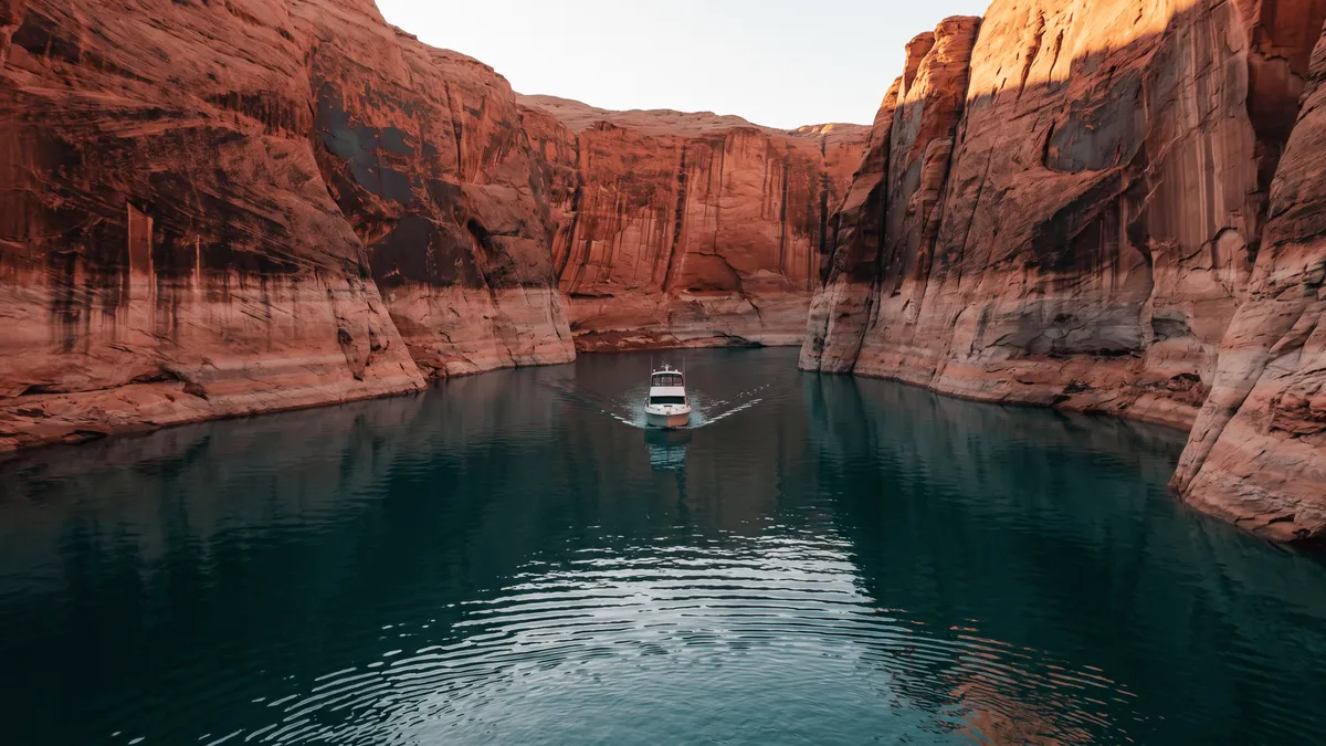
Navajo Canyon opens on the east side of Lake Powell’s main channel at buoy 10, about 5 lake miles above Antelope Point and Wahweap. It runs back 15.5 miles under 600-foot walls. It is not a wakeless zone, so a day boat can cover it at speed. Big boats stop short of the inflow at the end, and the drainage above the water is closed to hiking.
The canyon changes character as you work up it, and where you have to stop depends on what you are driving.
| Stretch | Roughly | What it is |
|---|---|---|
| Mouth at buoy 10 | mile 10 from the dam | East side of the main channel, 5 miles above Antelope Point |
| Lower and middle canyon | first 12 or so miles | Wide, deep, 600-foot walls, runnable at speed |
| Upper narrows | last 2 to 3 miles | Tightens; watch depth and turn a big boat around |
| Canyon end | the inflow | Flat bottom, spring driftwood — dinghy or kayak water |
| Above the water | the drainage | Navajo Nation land, closed to hiking and camping |
Where is Navajo Canyon on Lake Powell?
Navajo Canyon opens on the east side of the main channel at navigation buoy 10. The Park Service boating page is explicit about what that number means: “Numbers on main channel buoys are APPROXIMATE mileage from Glen Canyon Dam.” So the mouth sits about 10 lake miles above the dam. The NPS marinas page puts Antelope Point at about mile 5 and Wahweap at mile 5.5, which leaves roughly 5 miles of open channel between either ramp and the turn.
You get 5 miles of open channel and then 15.5 miles of canyon, which is why Navajo fills the awkward slot between a two-hour cruise and a committed run up-lake. Antelope Canyon sits closer to the ramps but is short and speed-limited. Labyrinth is up past Padre Bay.
Lake Powell Resorts calls it “one of the longest of Lake Powell’s 96 major side canyons” and “also one of the only side canyons to have been a tributary of the Colorado River.” The rest are washes. Navajo Creek was a river in its own right, and the size of the gorge shows it: walls about 600 feet over the water, laden with what the same page calls Navajo Tapestries — iron oxide and manganese streaks that ran down the sandstone from shale beds since eroded off the rim.
Per the Park Service ramp status dated 8/11/2026, the Antelope Point public ramp is “closed to motorized vessels” and “available for paddlecraft launching only,” and Wahweap Main reads the same. Stateline Auxiliary at Wahweap is the ramp open to houseboats and motorized vessels, so a trailered boat starts there and runs past Antelope Point on the way up. The marina itself is open and sells gas and diesel, and its valet service still launches boats around 23 feet and under — the Antelope Point marina guide has the detail.
How far up Navajo Canyon can you take a boat?
Most of it, and then you swap boats. The lower and middle canyon is wide, deep water that a houseboat or cruiser handles without drama. The last few miles are where people get in trouble.
Wayne Gustaveson, who ran the fisheries on this lake for decades, is blunt about the end of it in a Wayne’s Words post: “Bottom slope of the lake at the canyon end is flat making navigation to the hike point marginal at best.” His recommendation is to anchor the big boat and cover the shallow water in “an inflatable dingy launched from the big boat” or a kayak.
Spring is the worst time to try for the inflow. In his words: “In the spring, the narrow canyon with perennial inflow is choked with drift wood making navigation to the end very difficult.” A canyon with a live stream at the top collects everything that stream carries, and by late summer the driftwood has stranded out and boats get through to the inflow again. How far the water reaches at all moves with the lake, which you can check at lakepowellwaterlevel.com before you commit the day.
For most crews the sensible trip stops early: run the middle canyon, find a beach, swim, and skip the last two miles. If you want the inflow, bring something inflatable and go in the back half of summer.
Can you hike or camp in Navajo Canyon?
Two jurisdictions meet at the waterline here, with different answers.
The water and the shoreline are inside Glen Canyon National Recreation Area, and the NPS camping page is generous about it: “You can camp anywhere on the shorelines of Lake Powell except in developed marinas,” with “no camping fee or permit required.” Entrance and vessel fees still apply — $30 per vehicle for a week and $30 for a vessel 26 feet and under, per the park fee page. Every site needs a portable toilet unless there is one aboard or within 200 yards, and wood ground fires stay below the high water line at 4 feet by 4 feet.
The drainage above the lake is Navajo Nation land, and Navajo Nation Parks & Recreation starts from a closed default: “All areas on the Navajo Nation are closed to non-Navajos unless you have a valid camping, hiking, or backcountry permit issued by Navajo Parks and Recreation Department or other duly delegated tribal authority.” Then it names this canyon directly: “the Kaibeto Chapter community has prohibited hiking and camping in the entire area of Upper Kaibeto, Navajo Canyon, Choal Canyon, Kaibeto Creek, Peach Wash, and Butterfly Canyon.”
That closes the Chaol Falls hike, which still shows up in older canyon lists. It is a real walk — Gustaveson measured it at “4 miles one way,” about an hour to the fork and another to the falls, with wet feet the whole way — and as of mid-2026 it is not a trip you can plan. The closure carries no published end date, so call Navajo Parks at (928) 871-6647 for current word before you count on anything on foot past the beach.
Boat access is unaffected. It is the same split as Rainbow Bridge, where the land route needs a tribal permit and the water route does not. The Lake Powell canyons guide covers how that plays out across the lake.
Is Navajo Canyon better than Antelope or Labyrinth?
For a half day with a fast boat, yes. The reason is a wake rule. The NPS boating page names the wakeless zones: “Rainbow Bridge National Monument and Antelope, Labyrinth and Lost Eden Canyons are also wakeless zones.” Navajo Canyon is not on that list.
Idling a canyon this long at 5 mph would eat a day. At cruise you are at the narrows in well under an hour, with time to swim and get back. The regular wake rules still bind — no wake within 100 feet of another vessel, anchored or drifting included — and chop bounces off these walls instead of dying out, so a canyon that looks empty can still be lumpy in the afternoon.
The tradeoff is scale. Navajo runs wide the whole way. For a slot tight enough to touch both sides at once, go to Labyrinth Canyon off Padre Bay, covered in the Lake Powell canyons guide. Antelope Canyon is the short glowing-wall cruise you do in an hour. Navajo is the one you take a houseboat into.
If you would rather ride than pilot, Antelope Point Marina runs a 2-hour Navajo Canyon tour at $75 adult and $45 for kids 4 to 12, on scheduled dates rather than daily departures. Their pitch is “the dramatic cliffs and quiet beauty of Navajo Canyon” plus a view of Tower Butte. The 1-hour Antelope Canyon tour at $50 leaves far more often, so check dates before driving out to the marina.
Anglers get a bonus here. Wayne’s Words fishing reports have Navajo Canyon producing walleye on dark tube jigs worked along the bottom, on top of the smallmouth that hold on rock through the whole south end. One license covers both states — the fishing guide has the details.
What the run needs from you
Pick your turnaround before you leave the ramp. 15 miles of blind bends with no cell signal is where crews keep going because the next corner looks fine, then burn the last of their fuel getting home into a headwind.
The mouth is easy to miss on the way in. The east wall of the main channel here runs unbroken sandstone for miles, and a single buoy is small against it. The Navigator map holds all 132 named side canyons offline for this — mark the mouth and your anchor spot at home, and both are still on screen 12 miles in with no bars. Route planning out of the south marinas is covered in the trip planner.
Key takeaways
- Navajo Canyon opens on the east side of the main channel at buoy 10, about 5 lake miles above Antelope Point and Wahweap.
- At 15.5 miles it is one of the longest side canyons on Lake Powell, and one of the few that drained into the Colorado River as a tributary.
- It is not a wakeless zone, unlike Antelope and Labyrinth, so a day boat can cover it at cruise.
- Big boats should stop short of the inflow — the bottom flattens out there, and driftwood collects in spring.
- Shoreline camping is fine under Park Service rules; the Kaibeto Chapter has closed the canyon to hiking and camping on Navajo Nation land as of mid-2026.
Frequently asked questions
Where is Navajo Canyon on Lake Powell?
Navajo Canyon opens on the east side of Lake Powell’s main channel at navigation buoy 10. Main-channel buoy numbers are approximate miles from Glen Canyon Dam, per the Park Service, so the mouth sits about 10 lake miles above the dam — roughly 5 miles up-lake from Antelope Point Marina at mile 5 and Wahweap Marina at mile 5.5. That puts the turn within a half-hour run of either south marina. Trailered boats launch at Wahweap Stateline Auxiliary — the Antelope Point public ramp is paddlecraft-only as of 8/11/2026.
How long is Navajo Canyon?
The flooded arm winds back 15.5 miles from the main channel, which makes it one of the longest side canyons on Lake Powell and one of the few that drained into the Colorado River as a tributary rather than a wash. Lake Powell Resorts puts the walls at about 600 feet above the water, streaked with Navajo Tapestries — iron oxide and manganese stains that ran down the sandstone from shale beds that have since eroded away.
How far up Navajo Canyon can you take a boat?
Most of the 15.5 miles is comfortable water for a houseboat or cruiser. The last stretch is the problem. Wayne Gustaveson of Wayne’s Words describes the bottom slope at the canyon end as flat, making navigation to the inflow marginal at best, and recommends covering that shallow water in an inflatable dinghy or kayak launched off the big boat. In spring the narrow upper canyon chokes with driftwood carried down by the inflow.
Can you hike in Navajo Canyon?
Not beyond the shoreline, as of mid-2026. The canyon drainage is Navajo Nation land, and Navajo Nation Parks & Recreation states that the Kaibeto Chapter community has prohibited hiking and camping in the entire area of Upper Kaibeto, Navajo Canyon, Choal Canyon, Kaibeto Creek, Peach Wash, and Butterfly Canyon. That closes the old Chaol Falls walk out the back. Call Navajo Parks at (928) 871-6647 before planning anything on foot up the drainage.
Can you camp in Navajo Canyon?
On the Lake Powell shoreline inside Glen Canyon National Recreation Area, yes. The Park Service allows camping anywhere on the shorelines of Lake Powell except in developed marinas, with no camping fee or permit — entrance and vessel fees still apply. Every campsite needs a portable toilet unless there is one aboard your vessel or within 200 yards. Wood ground fires are allowed below the high water line, no more than 4 feet wide and 4 feet high.
Is Navajo Canyon a no-wake zone?
No. The Park Service lists Rainbow Bridge National Monument and Antelope, Labyrinth and Lost Eden Canyons as wakeless zones — Navajo Canyon is not among them. You can run it at speed, which is the practical reason it works as a half-day trip when the neighboring canyons do not. The general rules still apply: no wake within 100 feet of another vessel, anchored or drifting, and 5 mph in marinas and swim areas.
How much does the Navajo Canyon boat tour cost?
Antelope Point Marina runs a 2-hour Navajo Canyon boat tour at $75 per adult and $45 for children 4 to 12, on scheduled dates rather than daily departures. The marina describes it as the dramatic cliffs and quiet beauty of Navajo Canyon, with a view of Tower Butte. Their 1-hour Antelope Canyon tour is $50 adult and $30 child and leaves several times a day, so check the schedule before you drive out.
Mark your turnaround before you lose signal
The Navigator app keeps Lake Powell’s 132 named side canyons on an offline map, so you can drop a pin where you plan to stop in Navajo Canyon and still see it 12 miles in with no bars.