
Alstrom Point, Lake Powell: the drive and what it takes
Alstrom Point is 23 miles of dirt road out of Big Water, Utah, to a rim high above Padre Bay. The mileage log, the vehicle you need, and when to turn back.
Quick answer
Alstrom Point is a dirt-road overlook on Romana Mesa, on the west side of Padre Bay, above cliffs the Park Service puts at 1,000 feet. It runs about 23 miles of dirt each way from Big Water, Utah. The Park Service calls the round trip 46 miles and gives a minimum of 2 hours in each direction. High-clearance 4WD is needed for the last few miles, and wet weather can shut the road to 4WD as well.
The Park Service publishes a mileage log for the drive. Reset your odometer at Ethan Allen Road in Big Water and these are the marks that matter.
| Odometer | What’s there | Why it matters |
|---|---|---|
| 0.25 | Right turn onto the Smokey Mountain/Croton Road (Route 230) | Signed for Glen Canyon NRA and State Highway 12 |
| 0.80 | Wahweap Creek crossing | The vehicle test. Can’t clear it, turn around |
| 3.7 | Resurrection Canyon parking, balanced rocks across the road | First worthwhile stop |
| 4.9 | Wiregrass Canyon trailhead | 4-mile round-trip hike with cairn-following; the trail no longer reaches the water |
| 9.2 | Crosby Canyon turnoff (Route 231) toward Warm Creek Bay | Keep straight; that shoreline is closed to vehicles |
| 12.9 | Two junctions in quick succession | Bear right at both |
| 18.2 | Alstrom Point road (Route 264) on the right | Sign says the overlook is 5 miles ahead. Hit a cattle guard and you’ve gone too far |
| ~23 | Rim of Romana Mesa | Sandy rock, sheer drops, no railing |
How long does the drive to Alstrom Point take?
Budget the whole day. The Park Service puts the trip at 46 miles (74 km) round trip with a minimum of 2 hours each way, so about 4 hours behind the wheel before you stop to look at anything. Its published duration for the outing runs from 4 hours to 48; the long end covers people who camp up there for the light. The turnoff is in Big Water, across from the Big Water Visitor Center on US-89.
The Smokey Mountain/Croton Road gets graded periodically rather than on a schedule, so you cover those 18 miles on washboard and soft patches at whatever speed they allow. Route 264 is slower again, and its two published lengths measure different endpoints: the sign at the turnoff gives 5 miles to the overlook, while onX Offroad measures 6.9 miles for the whole road, which runs past the overlook to where the track ends. Drivers logging it there describe the last stretch as a rock garden. The Park Service also advises against driving the road at night, so if you aren’t camping, count 2 hours back from sunset for the return leg and start from there.
What vehicle do you need to get to Alstrom Point?
You want high clearance for the whole road and 4WD for the end of it. That’s the split the Park Service publishes: high-clearance 4WD is necessary for the last few miles, high-clearance 2WD is recommended for the entire drive. Recreational vehicles and trailers are not recommended anywhere on the route.
Wahweap Creek crosses the road at mile 0.80, and the Park Service is blunt about what that crossing means: a vehicle that can’t clear it can’t handle the rest of the drive. Turning around at mile 0.80 costs you an hour. A recovery from 20 miles in costs a good deal more.
Past the Route 264 turn the road degrades sharply. It fades into sandstone in places and splits into social trails, so you pick a line across the rock; the Park Service asks you to follow the largest of the existing tracks to keep the damage in one place. One driver logging the trail on onX in 2026 put the ledges at 8 to 14 inches with off-camber sections, and reports there run from stock 4x4 pickups and Wranglers getting through to a warning that a Subaru would not. If a ledge looks taller than your clearance, park at the first overlook and walk in. The Park Service says the same thing: there are several places with great views along the way, and you can walk the last couple of miles.
When is the road to Alstrom Point closed?
Wet weather can close it, and nothing announces the closure. Wet weather can leave these roads impassable to 4WD as well, and the Park Service road-conditions page carries one instruction: don’t take unpaved roads if it’s raining or snowing, or if rain or snow is forecast. Much of the lower road crosses Tropic Shale, the marine mudstone the Park Service points out for its Cretaceous fossils, and wet shale turns to grease with very little water in it. The mesa on top is Romana Sandstone.
Rain falling dozens of miles up the drainage arrives at that crossing hours later under clear sky — alstrompoint.com documents a flood there from 3 inches that fell six hours earlier and far to the north — and the Park Service warns that 6 inches of moving water can shift a vehicle if it is running fast enough. Get caught on the far side and you stay there until the creek drops, which the Park Service states plainly. Check the forecast for your return as carefully as for the drive out, and treat a monsoon afternoon between July and September as a reason to pick another day.
What can you see from Alstrom Point?
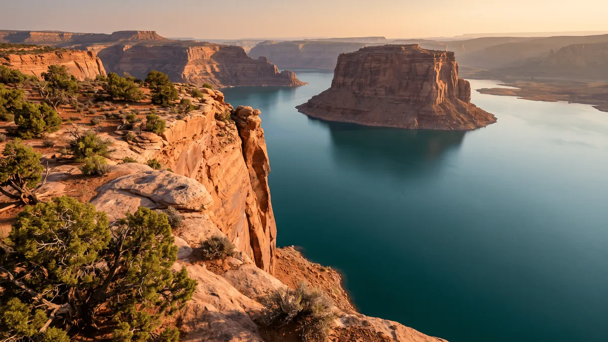
You look down into Padre Bay from the top of cliffs the Park Service puts at 1,000 feet. Padre is the largest open water on Lake Powell — Lake Powell Resorts and Marinas measures it 7 miles across and 9 miles long — and its mouth sits around lake mile 19, roughly 12 nautical miles up the main channel from Wahweap Marina. Gunsight Butte stands out of the water on the near side, and Cookie Jar Butte sits out in the bay. The Park Service uses the view of Gunsight Butte from Romana Mesa as the photograph for this drive.
The rim is unmarked and unfenced. Ground that looks like more sandstone can drop hundreds of feet a step later, and nothing up there blocks the sun. The Park Service names sunrise and sunset as the best light here, which is the argument for camping rather than day-tripping. The sunset spots guide covers the same light from the water, and the beaches guide covers the coves you’re looking down into.
Can you camp at Alstrom Point?
Yes, free, and with no permit. Alstrom Point is inside Glen Canyon National Recreation Area, where camping in undeveloped areas costs nothing and needs no reservation. The Park Service camping page caps it at 14 consecutive days and 30 days total in the park per calendar year. The 2026 compendium sets 60 days a year for dispersed lake-based stays and 30 for managed sites, so the 14-day limit is the number both agree on. Other parts of the park do need one, including the Escalante District and the Orange Cliffs Unit, and Romana Mesa is in neither. Few people make the drive, and alstrompoint.com reports plenty of sites up there with few of them taken.
The 2026 Superintendent’s Compendium adds two limits that trip up larger groups. Camping 100 feet or more from the shoreline and outside a campground caps you at 12 people and 3 vehicles, and a party over 12 has to split and camp at least half a mile apart. Camping within half a mile of a trailhead is prohibited, which rules out sleeping at the Wiregrass or Resurrection parking areas on the way in.
Campfires are legal on the mesa. The compendium opens the recreation area above the high-water line to campfires everywhere except the Escalante River drainage and the Orange Cliffs, and caps a fire at 4 feet across. Seasonal restrictions during fire danger override that, and the mesa is bare rock and scrub with no firewood to gather, so bring fuel and a stove and check for restrictions before you count on a fire.
How far you are from the water decides the waste rule. More than a quarter mile from the shore, the compendium lets you bury solid waste 6 inches down or pack it out in an engineered waste bag — . Romana Mesa is sandstone, so digging a 6-inch hole is close to impossible. That’s why the Park Service asks you to bring wag bags. Toilet paper comes out with you either way; burning it is prohibited. Our Lake Powell camping guide has the shoreline rules for the water side of the same park.
What to sort out before you leave pavement
Sort the entrance pass and the offline maps before you leave the highway. All Glen Canyon visitors need a pass. A standard 7-day pass is $30 per private vehicle; the $55 Glen Canyon annual is sold only to US citizens and residents; an America the Beautiful pass also covers entry, at $80 for residents and $250 for non-residents. The park is cashless. No entrance station sits on the Big Water route, and the Park Service lists no separate activity fee for the drive, so buy the pass beforehand rather than expecting to pay at a booth.
Getting a road report is the harder half. The Park Service road page sends you to the BLM, and the BLM lists the Big Water Visitor Center as open daily 8 a.m. to 4 p.m. The same agency announced in March 2026 that the center would close until further notice, and it now routes information questions to the Kanab Visitor Center at 435-644-1300. Call before you count on staff being at the turnoff.
Assume no signal from the moment you leave US-89. Coverage on this end of the lake is patchy and depends on line of sight even on the water, as our cell service guide lays out, and a phone app that streams its map can only show you tiles it already cached once the bars go. Download the map first, and tell someone at home when you expect to be back. The onX Offroad comparison covers how offline dirt-road mapping differs from offline lake mapping, since you need one on the way in and the other once you’re looking at the water.
Key takeaways
- About 23 miles of dirt each way, which the Park Service calls a 46-mile round trip at a minimum of 2 hours in each direction.
- High-clearance 2WD for the whole road, high-clearance 4WD for the last few miles. Failing the Wahweap Creek crossing at mile 0.80 rules you out; clearing it doesn’t promise you the rough end.
- Wet weather can leave the road impassable to 4WD as well, and rain upstream can raise Wahweap Creek behind you under a clear sky.
- Camping on the mesa is free and permit-free, capped at 14 consecutive days and at 12 people and 3 vehicles per party. Carry in water; there is no toilet and no shade.
- The view is Padre Bay, the largest open water on Lake Powell, from the top of 1,000-foot cliffs, with Gunsight Butte across from you and no railing anywhere.
Frequently asked questions
How long is the drive to Alstrom Point?
The Park Service calls it a 46-mile (74 km) drive, which is the round trip — its own mileage log runs about 23 miles each way from Big Water, Utah. It gives a minimum of 2 hours each way, so roughly 4 hours behind the wheel before you stop for anything. The log reaches mile 18.2 on the Smokey Mountain/Croton Road, then adds the signed 5 miles to the overlook on the Alstrom Point road. Big Water sits about 12 miles north of Glen Canyon Dam on US-89.
Do you need 4WD to get to Alstrom Point?
For the last few miles, yes. The Park Service says high-clearance 4WD is necessary for the final stretch and recommends high-clearance 2WD for the whole drive. A high-clearance 2WD vehicle can usually reach the first overlook in dry weather, which alstrompoint.com calls the 2WD stopping point, and turn around there. The road turns to slickrock and ledges near the end — one driver logging it on onX Offroad in 2026 put the ledges at 8 to 14 inches with off-camber sections, and another wrote that a Subaru would not make the last 2 miles.
Can a regular car make it to Alstrom Point?
Only partway, and only when the road is dry. The Park Service gives a self-test at mile 0.80: you cross Wahweap Creek there, and if your vehicle cannot clear that crossing, it cannot handle the rest of the drive. Beyond it the Smokey Mountain/Croton Road is graded periodically rather than regularly. The Park Service doesn’t recommend recreational vehicles or trailers anywhere on the route.
Is Alstrom Point worth it?
You get a road-accessible view down onto Padre Bay, the widest stretch of Lake Powell, without launching a boat. From the rim on Romana Mesa you stand on sandy rock above cliffs the Park Service puts at 1,000 feet, with Gunsight Butte standing out of the water across from you. The cost is roughly 4 hours of driving on dirt, with no facilities at the end of it and no reliable phone signal. The Park Service names sunrise and sunset as the best light and suggests camping to catch it.
Can you camp at Alstrom Point?
Yes, free and without a permit. Alstrom Point is inside Glen Canyon National Recreation Area, where camping in undeveloped areas carries no fee and no reservation, capped at 14 consecutive days in one spot, with the Park Service camping page giving 30 days total in the park per calendar year. The 2026 Superintendent’s Compendium caps a party camping away from the shoreline at 12 people and 3 vehicles. Romana Mesa has no toilet, no water and no shade, so carry everything in and pack all human waste back out — the Park Service asks specifically for wag bags.
Is there cell service at Alstrom Point?
Not reliably. The Park Service warns of limited service on the drive and calls coverage unreliable at the point, and the road drops into washes and low ground that block whatever signal you had on the flat. Download your maps before you leave pavement, because an app that streams its tiles can only show you what it already cached once the bars go. Leave your route and return time with someone who will notice if you miss it.
Do you have to pay to visit Alstrom Point?
You need a Glen Canyon entrance pass, but there is no extra charge for the drive itself — the Park Service lists no activity fee for Alstrom Point. A standard 7-day pass is $30 per private vehicle. The $55 Glen Canyon annual pass is sold only to US citizens and residents, and an America the Beautiful pass also covers entry, at $80 for residents or $250 for non-residents. No entrance station sits on the Big Water route, and the park is cashless, so buy the pass in advance or at a staffed station before you head out.
Put names on what you see from the rim
Lake Powell Navigator maps 20 named bays and 48 sight landmarks, so the buttes standing out of Padre Bay have names before you ever launch a boat.