
Cathedral in the Desert: reaching Lake Powell’s alcove by boat
Cathedral in the Desert is a 60-foot waterfall chamber up Clear Creek in Lake Powell’s Escalante arm. The run from Halls Crossing and the walk in, as of 2026.
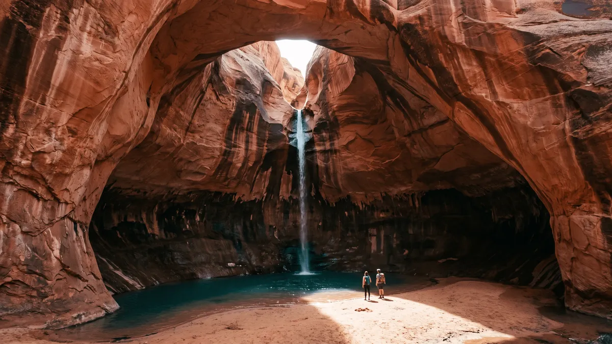
Cathedral in the Desert is a sandstone chamber with a waterfall of about 60 feet at the head of Clear Creek Canyon, about 4 miles up the Escalante arm of Lake Powell. From the north-lake docks it is 31 to 35 lake miles, about 2 hours in a powerboat or 5 in a houseboat. Rising water submerged it in the lake’s first decade; in 2026 the whole chamber is out of the water, so you boat to the end of Clear Creek and walk the last half mile up a sandy wash.
Where is Cathedral in the Desert?
At the back of Clear Creek Canyon, a side canyon of the Escalante River arm, on the Utah side of Glen Canyon National Recreation Area. The Escalante leaves the main channel at buoy 68, about 11 miles past Reflection Canyon and 2 miles past the Hole-in-the-Rock notch, and Clear Creek opens about 4 miles up the arm, going by a 2018 trip report and the USGS sampling station right above it (one boating write-up calls it 2.5). The chamber is at the head of the creek.
Aramark’s north-lake guide puts it “about 23 miles south of Bullfrog Marina”. The mile-marker math comes out higher: Bullfrog sits near buoy 95, the Escalante mouth is buoy 68, and Clear Creek is 4 miles beyond that, which lands closer to 31 lake miles by the channel. The Park Record estimated 35 from Bullfrog and 70 from Wahweap. Use 31 for the chart and 35 for the fuel math.
What does the run look like in 2026?
The north lake is the only sensible start. From Wahweap it is a 70-mile one-way run with no fuel after Antelope Point, because Dangling Rope is closed for good. From the north you launch and fuel in the same morning.
| Launch (NPS status, October 30, 2026) | Who can use it | Distance to Clear Creek |
|---|---|---|
| Bullfrog North ramp | All vessels, launch at your own risk | 31 to 35 lake miles |
| Bullfrog Primitive ramp | Closed; the dirt ramp is only usable when the lake sits lower than it does now | 31 to 35 lake miles |
| Halls Crossing ramp | Closed to all vessels | Closed |
| Stateline Auxiliary (Wahweap) | All motorized boats | ~70 lake miles |
The Park Service table is the one to check the morning you go. Bullfrog Main, Halls Crossing and both Antelope Point ramps are closed to motors at current levels, and the Charles Hall ferry is not running.
Fuel is at Halls Crossing. For 2026 the Bullfrog floating marina, its rental fleet and its fuel dock all moved about 3 miles across the channel to deeper water there, so if you launch at Bullfrog you top off on the Halls side before turning down-lake. Aramark’s own travel-time figures from Bullfrog are 5 hours by houseboat or 2 by powerboat; Halls Crossing is a few minutes closer. The fuel planner has the burn numbers for the round trip.
Once you turn into the Escalante, stay over the channel buoys. The arm narrows the farther up you go, and the Park Service notes that lower water means narrower channels and more congestion up-lake. Mornings are calm. Afternoons bring wind down the arm, so plan to be heading back out by early afternoon.
How far do you walk once the water ends?
About half a mile, up a sandy wash with a trickle of creek in it, and that number moves with the lake.
Two dated reports bracket it. In spring 2022, with the lake near where it sits now, the Park Record’s crew ran 70 miles from Wahweap and then made “a half-mile sandy hike along the well-vegetated yet tiny trickle of a stream that was Clear Creek.” In April 2023, at a similar level, a KUNC reporter rode a rented pontoon from Bullfrog, beached it at the mouth of the side canyon and walked about half an hour. By late summer 2023 the lake had come up 50 feet and the same crew floated into the chamber and up to the base of the falls.
So the walk is short and flat, soft underfoot. The end of the water is the slow part: the last stretch of any Escalante side canyon is mud and sediment, and the Park Service warns about quicksand at the Rainbow Bridge beaching for the same reason. Nose the boat in, test the bottom with a paddle before anyone steps off, and tie to something solid rather than trusting an anchor in silt.
Why does the walk change from year to year?
Because the chamber sits in the band of elevation the lake has been moving through since 2019.
The Glen Canyon Institute, which has tracked the site through the drawdowns since 2005, puts the steps at 3,605, 3,580 and 3,575 feet: the chamber starts to surface at 3,605, the waterfall is flowing free by 3,580, and at 3,575 there is a floor to stand on. Above 3,605 the Cathedral is a flooded alcove, and you idle a boat under the dome with the falls somewhere beneath your hull. Aramark’s guide still describes that version, with boats tying off above 3,620 feet and a “short walk up and over some ledges” into the chamber. In the band between, the falls are out and the pool at the bottom is a swim; Roadtrip Ryan found exactly that in 2025 at 3,561. At about 3,555 and below the Park Record’s “full Cathedral view” line is met, the floor is dry sand, and you walk in.
As of late October 2026 the lake is well under the 3,555 line, which is why USA Today could report the chamber visible from the air this month; for today’s number and the trend, see lakepowellwaterlevel.com. For your trip, that means the dry floor is what is on offer this season, and the walk gets shorter if the lake rises.
What is in the chamber?
A room of sandstone with walls the concessioner puts at about 1,000 feet, a domed ceiling that lets in a few slits of light, and a thin waterfall dropping 60 feet off a lip at the back into a cold pool. Dark streaks of desert varnish run up the walls like spires, and the name came from that resemblance. Burnett Hendrix and Harlon Beamont named it in the summer of 1954 on a trip up Clear Creek. David Brower called it “the ultimate magical place in Glen Canyon.”
Glen Canyon Dam closed in 1963 and the lake rose over the chamber as it filled, eventually putting close to 100 feet of water over the falls. The photographs most people know, Philip Hyde’s from 1964 (a year after the gates closed) and Tad Nichols’ from 1965, were made with the lake already rising toward the chamber. It surfaced briefly in 2005, went back under, reappeared in 2019, and has been in and out since 2022. The Glen Canyon Institute, which documents the site, says two years of low water and monsoon floods scoured about 20 feet of lake sediment off the floor and that ferns, willow and cottonwood had started coming back by 2023.
Gregory Natural Bridge, a mile up Fiftymile Creek at the mouth of the arm, is out of the water this year too, so a crew with time can see both on one run. The canyons guide covers the rest of the Escalante.
Can you get there without a boat?
Only as a canyoneering route, and it is a serious one. Roadtrip Ryan’s description drops into Clear Creek from Hole-in-the-Rock Road with 4 rappels, the longest 60 meters, and ends with a choice: a boat pickup at the water or fixed ropes to ascend back out. The access tags read 4x4 and high clearance, the flash-flood rating is high, and the season is spring or fall. Red Rock Adventure says the same in fewer words: the overland route “requires specialized knowledge and gear.”
If you want a walking approach to a Lake Powell landmark, Reflection Canyon has one, 15 to 18 miles round trip off the same road. Cathedral does not.
What to sort out before you leave the dock
- Fuel for the whole loop. Halls Crossing is the last pump. From there to Clear Creek and back is 62 to 70 lake miles, and you burn the same gas going home even if wind cuts the day short.
- Life jackets. The Park Service requires a properly sized PFD for every passenger, and children 12 and under wear theirs while the boat is underway.
- A portable toilet. Shoreline campsites need one unless the boat has a head or a toilet sits within 200 yards, and waste can’t go in a plastic bag unless it is an NPS-approved waste-bag system. Camping on the undeveloped shoreline is free, needs no permit and is capped at 14 consecutive days.
- A weather check for the whole Escalante drainage. Clear Creek is a flash-flood channel. Rain anywhere in its drainage shows up at the falls, and the sandy wash you walk in on is the floodway.
- Warm layers for the chamber. The pool is cold, the chamber is in shade most of the day, and in October the walk back out to the boat is the warm part.
- The turn marked. Clear Creek’s mouth is easy to miss from the channel, and there is no cell service anywhere in the arm. Set the waypoint on the offline map at the dock, with the mile-marker buoys as your backup.
A powerboat crew that leaves Halls Crossing at 8 am is at the end of Clear Creek by 10, in the chamber by 10:30, and back at the fuel dock before the wind. A houseboat does it as an overnight, anchored in the lower arm with the runabout doing the last few miles. Either way, go while the floor is dry.
Frequently asked questions
Is Cathedral in the Desert underwater?
Cathedral in the Desert is underwater whenever Lake Powell sits above about 3,605 feet of elevation; below that the chamber starts to surface, the waterfall runs free below about 3,580, there is a floor to stand on at 3,575, and the full view opens at roughly 3,555 and below. As of late October 2026 the lake is well under that line and the whole chamber is dry and walkable. The current elevation is posted at lakepowellwaterlevel.com.
Can you hike to Cathedral in the Desert without a boat?
Only as a technical canyoneering descent, and only for people who already do that. The land route drops into Clear Creek from Hole-in-the-Rock Road with a series of rappels, the longest about 200 feet, and you either climb back out on fixed ropes or get picked up at the water. Roadtrip Ryan rates the flash-flood risk high. For visitors without canyoneering experience it is a boat trip.
Is there a boat tour to Cathedral in the Desert?
No scheduled tour goes there as of late 2026. Aramark’s Wahweap tours run to Navajo Canyon, the dam and a private north-lake trip to Lost Eden, its Rainbow Bridge tour is suspended until further notice, and we found no outfitter listing a guided Escalante arm trip. You bring your own boat or rent a powerboat from the Bullfrog rental fleet, which works out of Halls Crossing for 2026.
Pin Clear Creek before you leave the dock
The Navigator app’s offline map names 132 side canyons, Clear Creek in the Escalante arm among them, so the turn is on your screen 30 miles from the nearest bar of service.