
Reflection Canyon by boat: reaching the overlook from the water
Reflection Canyon sits at buoy 57 on Lake Powell’s main channel. How boaters reach the famous overlook from the water instead of the 16-mile desert hike.
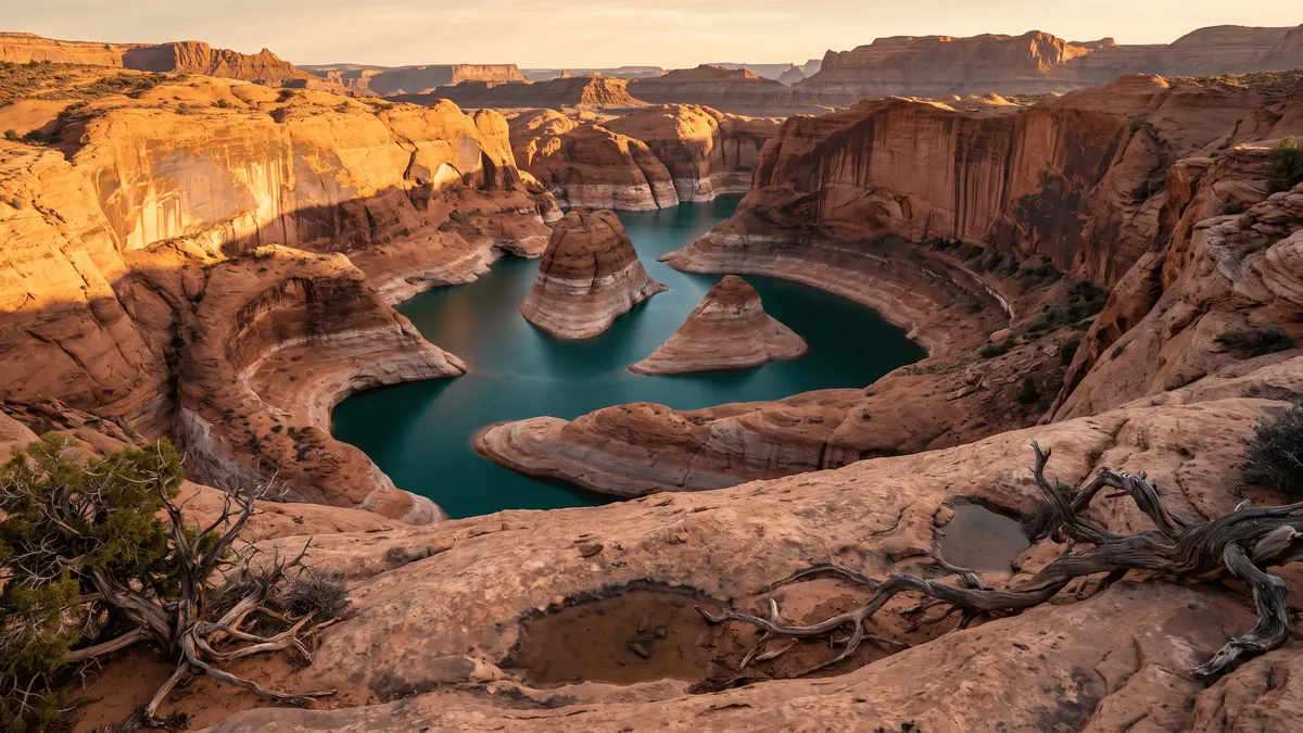
Quick answer
Reflection Canyon is a side canyon on the west bank of Lake Powell’s main channel at buoy 57, opposite the mouth of the San Juan. Boaters idle in, tie off in the shallows near the back, and scramble roughly 400 to 500 feet in about half a mile to reach the overlook. The land route is a 15 to 18 mile off-trail round trip from Hole-in-the-Rock Road.
Two routes lead to the same view of the same serpentine bend. One of them takes a boat and a half-mile climb. The other takes a high-clearance vehicle, a dirt road most of a day, and an all-day walk carrying your own water.
| By boat, buoy 57 | On foot, Hole-in-the-Rock Road | |
|---|---|---|
| Start | Wahweap (~52 lake miles) or Halls Crossing (~38) | Unmarked pull-off near road mile 50 |
| Getting there | Open main channel, then a shallow narrow entrance | 2 to 2.5 hours of washboard dirt from Escalante |
| Vehicle | Anything that can idle skinny water | High clearance; the road washes out wet |
| To the rim | ~0.5 mi, 400–500 ft of scrambling | 15–18 mi round trip, no trail |
| Water on route | You’re floating on it | None. Carry all of it |
| Permit | None for day use | Backcountry permit for overnight |
| What bites you | Fuel range, two exposed ridges | Heat, route-finding, remoteness |
Where is Reflection Canyon on Lake Powell?
Buoy 57, west bank, roughly across from the mouth of the San Juan River. Lake Powell boater references have listed it at mile 57 for decades, and the forum regulars at Wayne’s Words place it the same way — “across from the mouth of the San Juan River confluence near navigation buoy 57.” From Wahweap that’s about 52 miles of running up the main channel. From Halls Crossing it’s about 38 miles down.
Plenty of hiking write-ups put Reflection Canyon “in the Escalante arm,” and that will send you 11 miles too far up-lake. The Escalante River joins the main channel at buoy 68, and the historic Hole-in-the-Rock notch sits at buoy 66. Reflection is well below both, on the main channel itself. The confusion comes from the land side: the overlook is reached from Hole-in-the-Rock Road, which runs down the Escalante side of the plateau, and the whole area falls inside Glen Canyon’s Escalante District for permitting.
The name is younger than the canyon. Current USGS quads split it — the north fork is Cottonwood Gulch, while the main stem and south fork carry Reflection Canyon. River runners in the 1940s and 50s called the drainage Horse Canyon. Lake Powell mapmaker Stan Jones is generally credited with introducing “Reflection Canyon” around 1969, to separate it from Cottonwood Canyon up-lake. Then a 2006 National Geographic feature on Glen Canyon put the bend in front of a few million people and the argument was over.
Can you take a boat into Reflection Canyon?
You can, and the back of it is where the route to the rim starts. Boaters who have run it describe idling in from the main channel and working through a narrow shallow passage near the head of the canyon — prop trimmed up, holding the middle. One report clocked a shallow spot at 15 feet on the depth finder. Past that opens a wide shallow area with cottonwoods where you tie off and wade the last 50 feet or so in knee-deep water to reach sand.
None of that is fixed. What the shoreline looks like on the day you arrive changes season to season, and boaters have found the bank below the climbing route ending in a cliff instead of a beach. Check current conditions at lakepowellwaterlevel.com before you commit to the run.
There is no dock here, no ramp, no ranger and no fuel. The two nearest points of interest most boaters know are Rainbow Bridge, eight miles back down at the Forbidding Canyon turn, and the Escalante arm 11 miles further up, where the lower 12 miles of the Escalante River is boat-accessible and holds Cathedral in the Desert and the arch in Davis Gulch. Our Lake Powell canyons guide covers how that whole system fits together.
How hard is the climb to the overlook from the water?
Short, steep and worth taking seriously. The people who go this way put it at roughly 400 to 500 vertical feet in a half mile, carrying a pack — one guided group did it with 40 to 50 pound overnight loads. It’s slickrock scrambling rather than climbing, with hand holds along most of the exposed stretches, but there are a couple of ridge sections about a foot wide where you don’t want to slip.
The trade is stark. Half a mile of climbing against 15 to 18 miles of off-trail walking gets you to the same rim. Photographers who want the bend at sunrise and sunset have used the boat as a shuttle: dropped at the shore in the afternoon, camped on top, picked up the next morning. If you’re running your own boat, that means leaving it anchored overnight in a remote canyon, which is a decision about your ground tackle and the forecast more than about the hike.
Go in spring or fall. The Park Service warns of 35 to 55 mph gusts on the lake in spring, so the wind is a boating problem then rather than a hiking one — but a summer scramble up bare slickrock at midday in Glen Canyon is how people end up in trouble, and there’s no shade on the route at all. Our weather safety guide has the wind and storm thresholds for the rest of the lake.
What does the Hole-in-the-Rock Road hike involve?
The drive commits you before any walking starts. The trailhead is an unmarked pull-off near mile 50 of Hole-in-the-Rock Road, which leaves UT-12 a few miles east of Escalante. Budget 2 to 2.5 hours to drive it in dry conditions; the surface is washboarded dirt that gets worse toward the end and washes out after rain. High clearance is the standard recommendation, and it is not the kind of road you want to test a rental sedan on.
From there it’s about 15 to 18 miles round trip depending on the line you pick, and there is no trail. No blazes, no cairns you can count on, no signage at the overlook. There is also no water anywhere on the route, so everything you drink comes out of your pack. Most people carry overnight gear and camp near the rim rather than try it in a day, which turns it into a permit trip: overnight stays in Glen Canyon’s Escalante District require a free backcountry permit, available at Escalante-area visitor centers or by self-registration at trailheads. Day use needs none.
For the walking side of a boat trip generally, our Lake Powell hikes guide covers the trails you can reach from the water without any of this.
What does it take to plan the run?
Fuel, first. Dangling Rope Marina near buoy 40 was the mid-lake fill for decades and it is permanently closed, leaving roughly a 100-mile gap between the south-lake pumps at Wahweap and Antelope Point and the north-lake pumps at Bullfrog and Halls Crossing. Buoy 57 sits in the middle of that gap. For the 2026 season, Aramark moved Bullfrog’s floating marina and fuel dock into deeper water near Halls Crossing, with land-based services staying at Bullfrog — so if you’re coming from the north, the fuel is on the Halls side. Our distance guide has the run times at 10 and 20 knots.
Camping on the shoreline near the canyon mouth is allowed, with rules. The Park Service allows camping anywhere on the Lake Powell shoreline except developed marinas, capped at 14 consecutive days and 30 days total in a calendar year. Every campsite needs a portable toilet unless your vessel has one or a toilet sits within 200 yards, and solid human waste has to be contained and carried out in a portable toilet or an engineered bag system. Our camping guide has the full setup.
Then the part that catches people 50 miles from a marina: help is hours away. Assume no cell service on that stretch of the main channel. VHF channel 16 is how you reach the park in an emergency, and the Park Service asks boaters to leave a float plan — route and expected return — with someone on shore before a remote run. That advice does more work here than it does in Padre Bay. Our Rainbow Bridge guide covers the same fuel-and-range math for the other big uplake trip.
Key takeaways
- Reflection Canyon is at buoy 57 on the main channel’s west bank, opposite the San Juan mouth — about 52 lake miles from Wahweap, 38 from Halls Crossing, and 11 miles below the Escalante arm despite what most hiking blogs say.
- Boats can idle into the canyon and tie off in the shallows near the back; there is no dock, no fuel and no services, and the wade-in changes with the season.
- From the shore the overlook is roughly 400 to 500 feet of scrambling in half a mile, with two ridge sections about a foot wide — short, but not casual.
- The land alternative is a 15 to 18 mile off-trail round trip from an unmarked pull-off on Hole-in-the-Rock Road, with no water on the route and a backcountry permit needed to sleep out.
- Fuel for the round trip before you leave — Dangling Rope is closed for good and buoy 57 sits in the middle of the 100-mile gap.
Frequently asked questions
Where is Reflection Canyon on Lake Powell?
It is a side canyon on the west bank of Lake Powell’s main channel at navigation buoy 57, roughly opposite the mouth of the San Juan River. That puts it about 52 lake miles up from Wahweap and about 38 miles down-lake from Halls Crossing. Blogs often place it “in the Escalante arm,” which is wrong by about 11 miles — the Escalante joins the main channel at buoy 68, past Hole-in-the-Rock at buoy 66.
Can you get to Reflection Canyon by boat?
Yes. Boaters idle in from the main channel at buoy 57, pick their way through a narrow shallow section near the back, tie off in the shallows and wade the last stretch to the sand. There is no dock, no ramp and no services anywhere near it. From the shore it is a scramble of roughly 400 to 500 vertical feet in about half a mile to reach the overlook on the rim.
How hard is the climb from the water to the Reflection Canyon overlook?
Short and steep. Boaters who have done it describe about 400 to 500 feet of gain in a half mile of slickrock scrambling, carrying a pack, with a couple of ridge sections roughly a foot wide where a fall would be serious. There are hand holds most of the way and no technical climbing. Whether you can get ashore below the route in the first place changes with the season, and boaters have found the bank there ending in a cliff rather than a beach.
How long is the Reflection Canyon hike from Hole-in-the-Rock Road?
About 15 to 18 miles round trip, depending on the line you take, from an unmarked pull-off near mile 50 of Hole-in-the-Rock Road. There is no trail and no signage — the route is slickrock and sand with real navigation required. There is no water anywhere on it and no shade. Most people carry overnight gear and camp near the rim rather than push it in a single day.
Do you need a permit for Reflection Canyon?
Day use needs no permit. Overnight stays in the Escalante District of Glen Canyon National Recreation Area require a free backcountry permit, available at Escalante-area visitor centers or by self-registration at trailheads. Camping on the Lake Powell shoreline needs no permit but does require a way to contain solid human waste — a portable toilet, unless your boat has one or there is a toilet within 200 yards.
Is Reflection Canyon its real name?
Partly. On current USGS quad maps the north fork is Cottonwood Gulch and the main stem and south fork carry the Reflection Canyon name. River runners in the 1940s and 50s called it Horse Canyon, and Lake Powell mapmaker Stan Jones is generally credited with putting “Reflection Canyon” on the water around 1969 to keep it separate from the Cottonwood Canyon up-lake. A 2006 National Geographic feature on Glen Canyon settled the popular name for good.
Where is the closest fuel to Reflection Canyon?
Nowhere close. Dangling Rope Marina near buoy 40 is permanently closed, which leaves about a 100-mile fuel gap between Wahweap and Antelope Point in the south and Bullfrog and Halls Crossing in the north. For 2026, Aramark relocated the Bullfrog floating marina and its fuel dock to deeper water near Halls Crossing. Buoy 57 sits in the middle of that gap, so fill up before you leave and plan the round trip on one tank.
Mark the pull-in before you lose service
The Navigator app carries 132 named side canyons on an offline map, so you can drop a waypoint on the Reflection Canyon shoreline at home and still find it 50 miles up-lake with no bars.