
Defiance House at Lake Powell: boating to the Forgotten Canyon ruin
Defiance House is a 1250s Ancestral Puebloan dwelling 3 miles up Forgotten Canyon at buoy 106. The run from Bullfrog, the walk in and the site rules, as of 2026.
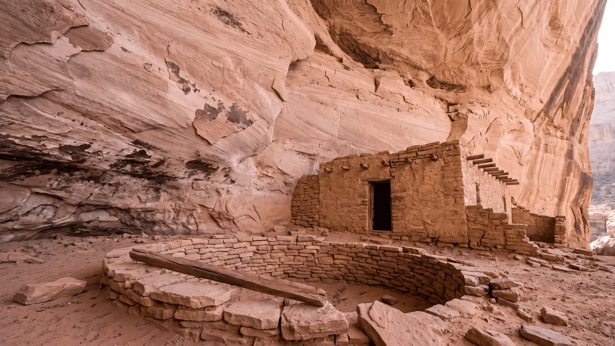
What is Defiance House?
Defiance House is an Ancestral Puebloan cliff dwelling occupied from about 1250 to 1285 AD, set in an alcove about 3 miles up Forgotten Canyon on the north end of Lake Powell. The canyon mouth is at buoy 106, 13 lake miles above Bullfrog and 12 above Halls Crossing. You boat up the middle fork until the water ends, beach, and walk 1 to 2 miles to a kiva, 3 rooms and a white pictograph of 3 figures holding shields.
Where is Forgotten Canyon?
On the east side of the main channel at channel marker 106, straight across from the mouth of Smith Fork and about 3 miles below Knowles Canyon. From Halls Crossing it is the third canyon on the right heading up-lake, about 12 miles. From Bullfrog the Park Service calls it about 13 miles on its Defiance House page and 15 miles, about 40 minutes on its hiking list; Aramark’s planning figures are 30 minutes by powerboat or 1.5 hours by houseboat from either marina.
A floating restroom and pump-out sit at the mouth (boaters reported it there in fall 2024), which is why the first stretch of the canyon sees traffic even in October. The canyon is one of the busier north-lake stops in summer; a Wayne’s Words moderator who ran all 3 arms in late September 2024 found 1 houseboat and 1 tent camp in the whole canyon.
Which fork has the ruin?
The middle one. Forgotten Canyon splits twice, and the Park Service directions are to take the middle fork until the water runs out. In practice:
- About three quarters of a mile in, a short arm opens on the right (south). It dead-ends, but Climb-Utah notes a small granary visible from the water on its wall. Binoculars help. Stay left.
- A quarter mile farther the canyon forks again. Take the right-hand branch. That is the middle fork, and Defiance House is about 1.5 miles up it, which puts the alcove 2.5 to 3 miles from the main channel depending on who is measuring.
- Boat until the water ends, then look for a place to tie up. Roadtrip Ryan warns the shoreline near the ruin is bushy some years and suggests tying off a little down-canyon on the right and walking.
At full pool the water reaches about 2.5 miles up from the main channel and runs past the ruin, close enough that boats tied up below it and people swam ashore. In April 2021 a long-time north-lake boater put the end of the water at about 1.5 miles from the channel, and the lake sits lower than that today.
How far is the walk in 2026?
Plan on about 2 miles each way, mostly flat, with a 150 to 200-foot climb at the end. The distance tracks the lake, and dated reports show how much it moves:
| When | Walk from the boat | Source |
|---|---|---|
| October 2003 | Almost a mile before the ruin came into view | Lake Powell Magazine, via Wayne’s Words |
| August 2018 | About 30 minutes each way | Pictures and Plane Tickets |
| October 2019 | About 2 miles round trip, 1 knee-deep crossing | Utah’s Adventure Family |
| September 2024 | A mile-plus each way, 30 to 35 minutes | Wayne’s Words |
| March 2026 | “Just under 2 miles each way” | Wayne’s Words trip report |
The March 2026 number is the one to budget for this season. The Park Service’s own hiking list rates it easy at 1 mile one way, with a note that the distance varies; Climb-Utah gives the ceiling, up to 2 miles each way at the lowest levels; and The Outbound logs the full outing at 4 miles round trip with about 200 feet of gain. For today’s elevation and the trend, see lakepowellwaterlevel.com.
The ground is the harder part. The first few hundred yards past the water are silt and dead cottonwoods, the trees that stood in the lake for decades and now stand in mud. One October 2019 group waded a knee-deep crossing 50 yards in, then followed an obvious trail up a sandy wash with a trickle of perennial stream beside it. Ghost trails branch off in the brush, so when in doubt stay on the main track along the stream. The pictographs show up high on the left wall before the structures do, and Park Service signs mark the switchback trail up to the shelf.
The compendium names the Defiance House Trail as a designated route you must use to reach the site. Follow the signs and stone steps rather than the scramble lines people have cut into the slope.
What is at the top?
The shelf holds a row of masonry rooms tucked under the overhang, a round kiva with a ladder dropping into it, and the painted wall above. The 1978 National Register nomination counts 1 kiva, 3 dwelling rooms and 4 granaries, built from shaped sandstone blocks set in tan adobe and plastered inside with red adobe, roofed with beams, poles and clay. A 2020 visitor’s informal count was two dwellings, a ceremonial kiva and several kitchen pits. You can climb down into the kiva; the timbers in the rebuilt roof are original.
The pictographs are the reason for the name. The headline panel is 3 large figures in white pigment holding shields and what look like clubs, which the Park Service describes as “three defiant figures with shields”. The nomination form’s inventory of the wall runs longer: 5 shield-and-club figures, a flute player, 6 sheep and a handful of geometric designs in red, white and gray. Look for the fainter figures once your eyes adjust.
The structures look complete because they were rebuilt. The Southwest Archeological Center in Globe, Arizona stabilized Defiance House in 1970, and the Park Service has maintained it since; Climb-Utah’s author, who first visited in the mid-1970s, credits that work with keeping it standing under the visitor load. The compendium lists it as 1 of only 5 archeological sites in the recreation area open for entering.
Who lived here, and how was it found?
Ancestral Puebloan farmers lived here, 1 or 2 extended families by Climb-Utah’s estimate, for about 35 years in the late 1200s. The pottery from the 1959 excavation included both Mesa Verde and Kayenta types, and the National Register form lists corn, beans, squash and cotton bolls among the finds, plus loom anchors, bows and bighorn sheep bone. The region emptied out at the end of the 13th century, and the Park Service notes that the builders’ descendants live today in the Hopi mesas, the Rio Grande valley and western New Mexico.
The canyon itself was missed on paper. The USGS river survey of 1921 mapped Glen Canyon with 20-foot contours and left the canyon across from Smith Fork off the sheet, which is how a river party in the early 1950s came to name it Forgotten Canyon; a Wayne’s Words history credits Dudy Thomas with the name after Harry Aleson had proposed “No Name Canyon.” That party found the ruin and called it Three Warrior Ruin.
The scientific record starts in 1959, when University of Utah archeologists surveying ahead of the rising lake climbed a hand-and-toehold trail into the alcove and found, in the Park Service’s telling, that “most of the roofs were still in place, and… two perfect red bowls still had scraps of food in them.” They renamed it Defiance House for the shield panel. Because the alcove sits above full pool, it survived the filling of the lake that drowned most of the other sites in the canyon, and it went onto the National Register in 1978. The pre-dam history post covers what else went under.
What are the rules at Defiance House?
The Park Service lets you inside the walls, which is rare, and attaches conditions. From the site page and the compendium:
- Enter, but don’t load the walls. No sitting, leaning or standing on masonry. Use the ladder and the doorways.
- Hands off the rock art. No touching, no chalking, no carving. The Park Service says graffiti at petroglyph sites is its most common form of damage and can’t be repaired.
- No pets, no food, no bathroom breaks at Defiance House. Handle all three at the boat.
- Stay on the designated trail. The Defiance House Trail is listed by name in the compendium as the required route.
- No camping on the site and no fires within 300 feet of it, under the compendium’s rules for archeological sites.
- Leave potsherds where they lie. Removing artifacts is a federal crime under the Archaeological Resources Protection Act, and the Park Service asks you to report disturbance at a marina, ranger station or visitor center.
A ranger is sometimes posted at the ruin in season, with artifacts from the excavation to show; 2 visitor accounts, from 2012 and 2018, describe one. Few people make the walk when it runs long, so you will often have the ruin to yourselves, and it stays open only as long as visitors follow the rules with no ranger in sight.
Launching and fuel on the north lake this season
The north lake is the only sensible start: you launch at Bullfrog North and fuel at Halls Crossing. From Wahweap it is a 100-mile run each way with no mid-lake fuel. The Park Service ramp table on October 30, 2026 reads:
| Launch | Status | Who can use it |
|---|---|---|
| Bullfrog North ramp | Open, launch at your own risk | All vessels |
| Bullfrog Main ramp | Closed to motors | Paddlecraft only |
| Halls Crossing ramp | Closed | No vessels |
| Charles Hall ferry | Not running | — |
Check the table the morning you go; it changes with the lake. For 2026 the Bullfrog floating marina, its rental fleet and its fuel dock are operating across the channel at Halls Crossing, so if you launch at Bullfrog North you top off on the Halls side before heading up-lake. The round trip to Forgotten Canyon is 24 to 26 lake miles plus a few inside the canyon, an easy morning for a powerboat; the fuel planner has burn rates if you are chaining it with Moki or Iceberg.
Inside the canyon, idle once the walls close in and keep a lookout on the bow for dead trees; the last quarter mile is soft bottom. The canyons guide covers running any side arm, and Cathedral in the Desert is the other north-lake walk-in, 31 miles the other direction.
What to sort out before you leave the dock
- Bring water, hats and closed shoes. A 2018 party watched teenagers start the walk barefoot with no water in August heat and talked them out of it. It is a desert wash, about 4 miles out and back this season.
- Start early in summer. The alcove is shaded and the walk is in full sun. Leave the marina at first light and be back on the water by late morning.
- Check the weather for the whole drainage. Roadtrip Ryan rates the flash-flood risk low, but the trail is the stream bed and a 2003 visit found a week-old flood had buried a no-wake buoy in debris. Skip it if storms are forecast anywhere up-drainage.
- Camp in the canyon if you want a slow version. The 3 arms of Forgotten hold houseboat spots, and shoreline camping inside Glen Canyon is free with a portable toilet and a 14-night cap; the camping guide has the rules.
- Keep walking if you have the time. Past the ruin the trail follows a perennial stream between 300-foot walls, and Lone Pine Fork, the first left about 1.5 miles beyond the alcove, ends under a 300-foot dryfall with a pool at its base. Hardly anyone goes past the ruin.
Give it a half day from Bullfrog: 40 minutes up the lake, 2 hours of walking, half an hour in the alcove, and the run home before the afternoon wind.
Frequently asked questions
Is Defiance House open to visitors?
Yes, as of late 2026. The Glen Canyon superintendent’s compendium lists Defiance House as one of 5 archeological sites in the recreation area that visitors may enter, and the Park Service page says you may go inside the structures. The Park Service closed it to foot traffic in August 2019 when low water and unstable ground made the approach unsafe, so check the park alerts before a long run. There is no gate, ranger station or fee at the site; access is by private boat and the Defiance House Trail.
Can you take a dog to Defiance House?
No. The Glen Canyon compendium closes all archeological sites to pets, and the Park Service directions for Defiance House say not to bring pets, food or restroom needs up to the ruin. Leave the dog on the boat with shade and water, or have one person stay back with it. The walk from the water is 1 to 2 miles each way in sun, so a dog left on a beached boat needs checking on.
Is there a boat tour to Defiance House?
No. The Park Service states that no roads, flights or tours go to Defiance House and that it is reachable only by private vessel, and as of October 2026 no marina or outfitter lists a guided Defiance House trip. You bring your own boat, rent a powerboat from the Bullfrog fleet, which operates from Halls Crossing for 2026, or paddle in from a houseboat anchored in Forgotten Canyon.
Mark Forgotten Canyon before you lose signal
The Navigator app’s offline map names all 132 side canyons and the numbered buoys, so the turn at marker 106 stays on your screen 13 miles from the marina with no cell service.