
Padre Bay, Lake Powell: crossing the widest water on the lake
Padre Bay is 7 miles across and 9 miles long, about 12 nautical miles up-lake from Wahweap. The buttes standing in it, where to beach, and when to cross.
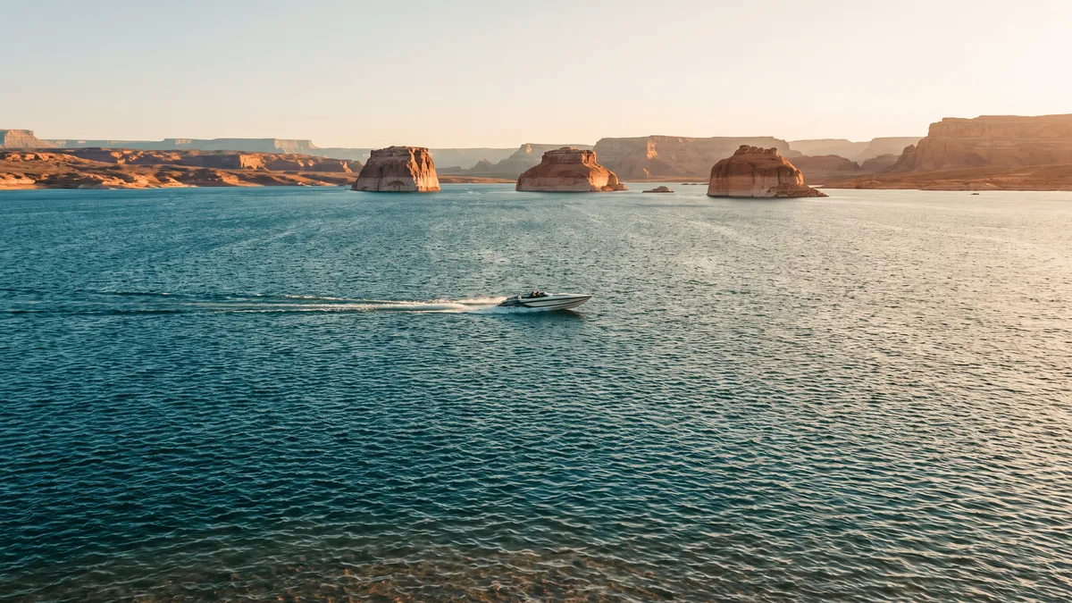
Quick answer
What you pass in Padre Bay
| Landmark | Where it sits | What it is to you |
|---|---|---|
| Labyrinth Canyon | South side, near buoy 18, at the mouth of the bay | Wakeless slot, narrow enough to touch both walls |
| Gunsight Butte | West side of the bay | The landmark you steer by on the way up |
| Gunsight Canyon | Under the butte, west side | About 2 miles of sandy beach, houseboat anchorage |
| Cookie Jar Butte | Out toward the middle | Boaters come ashore near it |
| Padres Butte and Padre Point | South shore | The old river ford was a mile west of the butte |
| Dominguez Butte | South side, toward the channel | Named for the 1776 expedition; marks a stage-dependent cut-through |
| Boundary Butte | South, at the state line | Lake Powell Resorts calls it astride both Utah and Arizona |
| Alstrom Point | High on the west rim | Road-access overlook, no boat needed |
| Gooseneck Point | East side of the bay | The headland that closes the bay on the east |
| Face Canyon | West of the bay | Quieter water; 2.5 or 4.5 hours by houseboat depending which operator page you read |
| Padre Canyon | Off the bay | Extensive sandy shoreline, canyon walls that block monsoon wind |
| West Canyon | Buoy 25, above the bay | Hiking canyon, 7 miles further up the channel |
How far is Padre Bay from Wahweap, and how long is the run?
About 12 nautical miles, which our distance guide puts alongside the other south-lake legs. In a powerboat that is about 40 minutes at a 20 mph cruise, well over an hour if you idle up at 10. A houseboat is a different trip: Lake Powell Resorts budgets roughly 4 hours uplake from Wahweap to Padre Bay, and warns it can take up to 5 hours to come back down from mile marker 25. Padre Bay opens where the main channel quits being a canyon, a little above buoy 18. Main-channel buoy numbers are approximate lake miles from Glen Canyon Dam, so call the mouth mile 18 or 19 and the bay runs up from there.
Getting on the water is the harder half. The Park Service access table, updated September 21, 2026, listed Wahweap Stateline Auxiliary as the single south-lake ramp available to motorized vessels. Wahweap Main and Stateline Main were open to paddlecraft only, the Antelope Point public ramp was closed to motors, and Halls Crossing was closed to everything. The Antelope Point business ramp reads closed too, with a note that the park does not run it and that limited launching may be available through Antelope Point Valet Services — a phone call rather than a ramp you can drive to.
Castle Rock Cut, the dug channel that shortcuts from Wahweap Bay into Warm Creek Bay, read closed on the same table. That puts the long way around Antelope Island back in the trip, which the Park Service costs at roughly 12 miles and an hour or more of extra running each way.
Fuel matters past this point. Dangling Rope, the old mid-lake fuel stop, is closed, so the next fuel dock above Padre Bay is Bullfrog, about 96 lake miles up from Glen Canyon Dam. For a south-lake day that makes the bay a round trip on the tank you left the marina with.
What are the buttes standing in Padre Bay?
Gunsight Butte sits on the west side of the bay, above the notch that names the canyon underneath it. Lake Powell Resorts & Marinas says the early river runners named that notch before the dam, for its resemblance to that part of a firearm. Out toward the middle stands Cookie Jar Butte, and the operator lists Dominguez Butte, Tower Butte and Boundary Butte among the monuments in view, describing Boundary as sitting astride both Utah and Arizona. Tower Butte stands well back from the water, so it reads as a horizon landmark rather than something you pass.
The rest of the names come from 1776, when the Franciscan priests Francisco Atanasio Dominguez and Silvestre Velez de Escalante forded the river here. Padres Butte stands on the south shore at the tip of Padre Point, Dominguez Butte carries the first of those two names, and the bay itself is named for the padres.
Two viewpoints look down on Padre Bay from the rim. Alstrom Point stands on the west side, on top of cliffs the Park Service puts at 1,000 feet, with Gooseneck Point closing the bay on the east side. Alstrom is reachable by dirt road — 23 miles of it each way out of Big Water, Utah, covered in our Alstrom Point guide.
When does the wind make Padre Bay rough?
Most days it starts in the early afternoon. Open water gives wind 7 miles of fetch here, so a breeze that does nothing in a side canyon has room to build real waves. The Park Service safety page warns of 35 to 55 mph gusts during spring wind events and puts the rule plainly: high winds can make large waves, so pull over and wait if winds are strong. Approach large wakes at a 45-degree angle. The Park Service puts the pattern as afternoon storms rising out of calm mornings. Paddlers writing up trips on r/LakePowell put a clock on it, reporting the wind up soon after midday and planning to run in the morning and sit out the middle of the day on a beach.
Response time is the second problem. The Park Service says rangers cannot travel until the storm is over, so a boat swamped in the middle of Padre Bay sits there until the wind drops. Its advice to paddlers crossing open water is to go as a group and watch for oncoming boat traffic, and a small powerboat has the same reasons to do it.
Two practical habits cover most of it. Check the marine forecast at the marina before you untie, and pick your bail-out shore before you start across, while it is still a map question. Gunsight Canyon on the west side and the mouth of Labyrinth on the south are both reachable from the middle of the bay. Use them for wind. If the forecast is thunderstorms instead, stay out of the narrow canyon itself. The Park Service is blunt about it: stay out of narrow canyons when flash floods are predicted.
Where can you beach or camp in Padre Bay?
Gunsight Canyon is the obvious houseboat anchorage off the bay, on Lake Powell Resorts’ own description — about 2 miles of sandy beach under a notch Lake Powell Resorts puts some 800 feet above the water, sheltered from what the main bay is doing. Face Canyon is the longer run, and you go for high walls and summer shade. Even the operator cannot settle how long that run is: its points-of-interest page says about 2.5 hours from the marina by houseboat, its 5 to 7 day itinerary says roughly 4.5 hours uplake. Padre Canyon is the one that itinerary calls a guest favorite, for an extensive sandy shoreline and canyon-wall protection from monsoon wind. For the bay itself the same page says most coves sit along the northern shoreline. Last Chance Bay, further up, has the big sand. Our camping guide covers Face Canyon and Last Chance in detail.
The rules are the same all over the lake, and 4 of them bite hardest on a beach camp:
- Toilet. Every campsite needs a portable toilet unless there is one aboard the vessel or within 200 yards, and the Park Service also accepts an approved waste-bag containment system. Packing out human waste is required within a quarter mile of the shore of Lake Powell, and burying waste on the beach is prohibited.
- Fire. Fires are allowed along Lake Powell’s shoreline below the 3,700-foot high-water level, outside the developed areas, and no more than 4 feet wide and 4 feet high. Burn wood and nothing else, keep glass out of the pit, and take all trash with you. Driftwood off the shoreline is fair game. Temporary fire restrictions override the standing rule, so check the park alerts before you count on one.
- Anchors. Pin anchoring is prohibited throughout Glen Canyon. The Park Service treats a pin hole in sandstone as defacing the rock, because water works carbonate out of the stone around it.
- Spacing and overhangs. The Park Service camping page says houseboats on the same beach should park at least 100 feet apart to cut carbon monoxide buildup, and not to camp under overhanging rocks, where downpouring rain can sink a vessel.
There is no fee and no permit for undeveloped shoreline camping on Lake Powell.
What is the Crossing of the Fathers, and is anything left of it?
Nothing you can see from a boat. Before the dam, a set of sandbars at a bend in the Colorado made one of the few places a horse could walk across. The Park Service says local peoples used the crossing for thousands of years before 1776, and it carried the name Ute Ford before it carried a Spanish one. In 1776 the Franciscan priests Francisco Atanasio Dominguez and Silvestre Velez de Escalante came through on the way back from a failed attempt to reach Monterey, California, forded the river there, and put the crossing in the written record as El Vado de los Padres. The ford sat about a mile west of Padres Butte, which stands at the tip of Padre Point, and the bay took its name from the men who crossed it.
Lake Powell covered the site when Glen Canyon Dam filled. How much water is over it now is a lake-level question, tracked over at lakepowellwaterlevel.com.
What this means for planning the day
Padre Bay sits across the route to most of the south lake. Nearly everything above it — West Canyon, Last Chance Bay, the long run to Rainbow Bridge — starts with crossing it, and the crossing is the leg wind can cost you. A morning departure from Wahweap usually puts you across the open water before the wind has built, and a beach in Gunsight or Face gives you somewhere to sit out the afternoon.
Coverage out here is sightline-dependent. Verizon reads well on the open bay and thins once you tuck into Gunsight or Labyrinth, which our cell service guide breaks down by carrier. The named buttes are labeled offline either way in the Navigator app, alongside the marina wind forecast you should have read at the dock. Sunset in Padre Bay is worth planning for on its own terms, and our sunset guide does the math on the run home in the dark.
Key takeaways
- Padre Bay is 7 miles across and 9 miles long, about 12 nautical miles up-lake from Wahweap: roughly 40 minutes in a powerboat, around 4 hours in a houseboat.
- The mouth is a little above buoy 18, where the main channel stops being a canyon; buoy numbers approximate lake miles from Glen Canyon Dam.
- Wahweap Stateline Auxiliary was the one south-lake ramp available to motorized vessels on September 21, 2026, with Castle Rock Cut closed.
- Wind is the variable that ends days here. Cross in the morning, expect the afternoon to build, and know which shore you would run for.
- Gunsight Canyon has about 2 miles of beach on the west side and is the standard place to sit out the wind or spend the night.
Frequently asked questions
Where is Padre Bay on Lake Powell?
Padre Bay is the broad open water on the main channel above Wahweap, in Kane County, Utah, with the Arizona line running through the buttes on its south side. The U.S. Geological Survey places it 13.5 miles northeast of Glen Canyon Dam. On the water you find it where the channel stops being a canyon and opens out, a little above buoy 18 — main-channel buoy numbers are approximate lake miles from the dam, so the mouth sits around mile 18 or 19.
How far is Padre Bay from Wahweap Marina?
Padre Bay is about 12 nautical miles up-lake from Wahweap Marina, or roughly 40 minutes in a powerboat at a 20 mph cruise and well over an hour if you idle at 10. A houseboat is a longer proposition, around 4 hours uplake by the operator’s own estimate. Getting on the water is the harder half in 2026. The Park Service access table listed Wahweap Stateline Auxiliary as the only south-lake ramp available to motorized vessels on September 21, 2026, with Castle Rock Cut closed, so the trip starts with the long way around Antelope Island. The Antelope Point business ramp is listed closed too, though the park notes limited launching may be available through Antelope Point Valet Services.
What are the buttes in Padre Bay called?
Gunsight Butte stands on the west side of Padre Bay, above the notch that gives Gunsight Canyon its name. Cookie Jar Butte sits out toward the middle of the bay, and Dominguez Butte and Padres Butte carry the names of the 1776 Spanish expedition. Boundary Butte sits astride both Utah and Arizona, per Lake Powell Resorts & Marinas. Tower Butte stands well back from the water as a landmark rather than something you pass.
Does Padre Bay get rough?
Padre Bay gets rougher than the canyons because 7 miles of open water gives wind that much distance to build waves. The Park Service warns of 35 to 55 mph gusts during spring wind events and tells boaters that high winds can make large waves, to pull over and wait, and to approach large wakes at a 45-degree angle. Paddlers on the lake report the wind coming up soon after midday. Rangers cannot travel until a storm is over.
Can you camp on the beaches in Padre Bay?
Yes, and there is no fee or permit for undeveloped shoreline camping on Lake Powell. Gunsight Canyon, off the bay’s west side, has about 2 miles of sandy beach. Every campsite needs a portable toilet unless a toilet is aboard the vessel or within 200 yards, with an approved waste-bag containment system accepted instead, and packing out human waste is required within a quarter mile of the shore. Burying waste on the beach is prohibited, and so is pin anchoring anywhere in Glen Canyon.
What is the Crossing of the Fathers?
The Crossing of the Fathers is a ford of the Colorado River, known as the Ute Ford and used by local peoples for thousands of years before it was recorded in 1776 by the Spanish priests Francisco Atanasio Dominguez and Silvestre Velez de Escalante, on their way back from a failed attempt to reach Monterey, California. It sat about a mile west of Padres Butte, which stands at the tip of Padre Point, and Padre Bay is named for the padres who crossed there. Lake Powell covered it when Glen Canyon Dam filled, and there is nothing to see from a boat.
Is there a shortcut from Gunsight Bay into Padre Bay?
There is a cut-through at the mouth of Gunsight Canyon, and a second crossing of the ridge between Padre Butte and Dominguez Rock. Both are stage-dependent. Wayne Gustaveson, who ran Lake Powell fisheries for Utah for decades, describes passing about 10 yards to the right of the white rock buoy going uplake, or to the left coming down, which is where the deepest water sits. Houseboaters on his forum reported running it in 2017 and 2019. Treat both as closed unless someone who has run one recently tells you otherwise.
Name the rock before you pass it
Lake Powell Navigator carries 20 named bays and 48 sight landmarks on an offline map, so Cookie Jar and Dominguez have labels whether or not the map tiles load out on the bay.