
West Canyon, Lake Powell: how to boat in and hike the narrows
West Canyon sits at buoy 25, 25 lake miles above Glen Canyon Dam. How far a boat gets in, where you beach it, and how far up the narrows you should go.
Quick answer
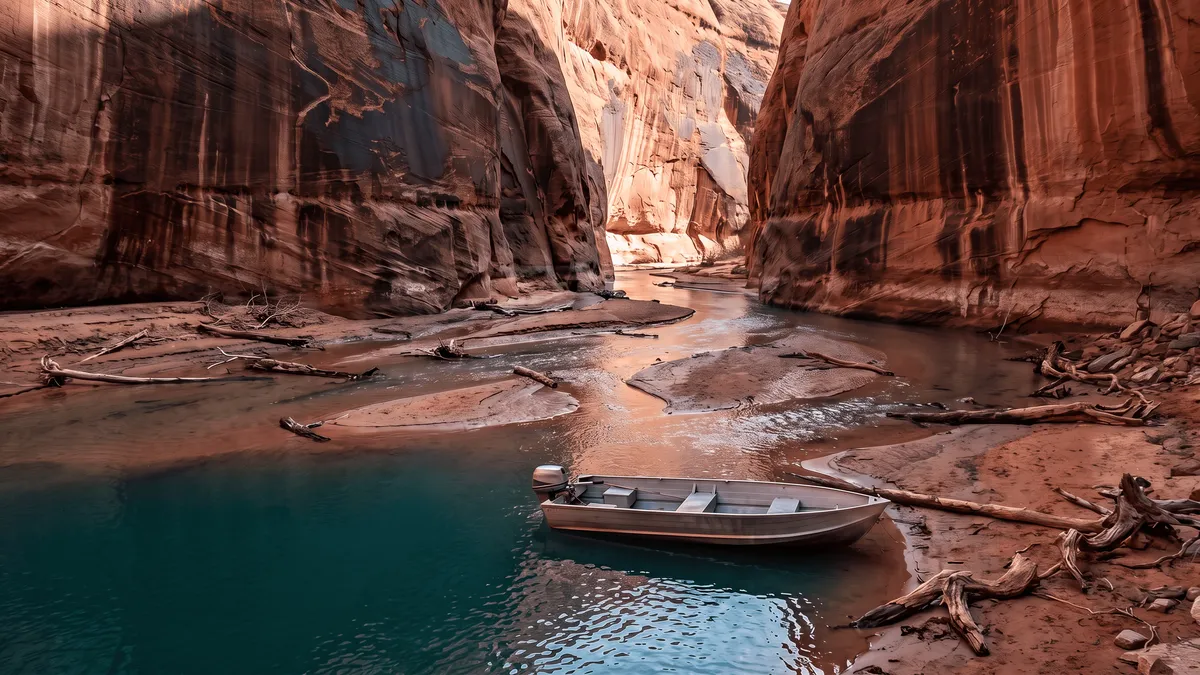
West Canyon opens on the west side of Lake Powell’s main channel at buoy 25, about 25 lake miles above Glen Canyon Dam and a short run from Wahweap or Antelope Point. Boats idle several miles into the flooded lower canyon, then you beach and walk. The first mile and a half is easy sandy wading. Past that it turns into pools, small waterfalls, and swimming.
The boat only gets you to the start of West Canyon. It changes character in stages as you walk up from the water.
| Section | Roughly | What it is |
|---|---|---|
| Flooded lower canyon | 6+ miles from the mouth | Boat water when there is enough of it — where you idle in and anchor |
| Sandy wash | first 1.5 miles on foot | Ankle-deep stream over sand bars, easy walking, quicksand pockets |
| First falls and pools | about 1.5 to 3 miles in | Scrambles up ledges around 7 feet, pools you wade or swim |
| The swim | 3 to 4 miles in | A water-filled slot; a bypass trail climbs around it |
| Roped falls | past the swim | Two drops of 10 to 15 feet with fixed lines around the corner |
| Upper narrows | about 11 miles in | Canyoneering: rappels to 23 feet, wetsuit, 3 to 4 days |
Where is West Canyon on Lake Powell?
West Canyon opens on the west side of the main channel at buoy 25, about 25 lake miles up from Glen Canyon Dam. Lake Powell Resorts, the marina operator, puts it at “about 25 miles up lake from Glen Canyon dam,” and Utah.com’s hiking page agrees at 25 with a trailhead coordinate of 37.04013, -111.21516. Main-channel buoy numbers approximate miles from the dam, per the NPS boating page, which makes buoy 25 roughly 20 miles above Wahweap and Antelope Point.
That is the whole appeal for a day boat. You are past Padre Bay and the crowds, still inside a comfortable fuel range from the south marinas, and the canyon behind the mouth runs back along the west side of Cummings Mesa for miles. Face Canyon sits down-lake, Last Chance Bay up-lake.
Utah.com is direct about access: “Boating is the only reasonable way to get into this canyon.” There is no road to it and nowhere to park. If you are launching from the south end, the Wahweap marina guide covers ramps and fuel before you go.
How far up West Canyon can you take a boat?
Six or more miles into the gorge when the water allows, per Utah.com. That number moves with the lake — how far in you get this season depends on where it is sitting, which you can check at lakepowellwaterlevel.com before you commit a day to it.
Two practical warnings from boaters who have done it. First, flood debris: a Wayne’s Words member reported “a massive amount of wood and flash flood material just short of the end of the lake” in 2023, which turned the usual easy walk up the stream bed into an obstacle course. A follow-up that June found the debris still there but confirmed that slow idling still reached good sandy anchoring spots.
Second, anchoring manners. The back of West Canyon is narrow, and an experienced hiker in that same thread made the point plainly: don’t park in a way that blocks access for others. A badly placed boat can trap the party behind you and leave hikers unable to get back to their own boat. Anchor wide, leave the channel open, and take the extra two minutes.
Big boats should stop where they can still turn. If you brought a kayak, this is the canyon to use it in — the kayaking guide covers water-taxi shuttles out here, since paddling out from Antelope Point is a 5-day commitment before you have hiked anything.
What’s the hike like from where you beach the boat?
Easy at first, then it turns serious fast. The first mile and a half is a sandy canyon floor with a shallow stream braided across it, walking between sheer caramel walls, per Red Rock Adventure’s account. Plenty of people walk that stretch barefoot. The one hazard in it is quicksand — water-saturated sand that, in their words, “allows your foot to penetrate easily, then holds on with a vacuum grip.”
Beyond the first mile the walls close in and you start meeting water you can’t walk around. There are swimming holes, a 7-foot waterfall you climb straight up the face of, and dark slots deep enough to swim through. Boaters in 2023 measured 4.4 miles from their landing to the pools under that year’s conditions — a 9-mile round trip on foot, with about 150 feet of cold swimming at the end.
Push further and it becomes a backpacking route. A party in April 2025 hiked 7.2 miles to camp and about 11 miles one way to the upper narrows, hitting a water-filled section that requires swimming around 3 to 4 miles in, with a high bypass trail for anyone whose gear can’t get wet, then two waterfalls of 10 to 15 feet with fixed ropes around the corner.
Treat those ropes carefully. A canyoneering trip report from the upper canyon found the anchors generally sound but the lines themselves semi-rotted boating rope. Test before you weight anything, and don’t assume a line hung by strangers is current.
How hard is West Canyon, and where should you turn around?
Utah.com rates the hike strenuous with a variable length, which is the honest answer: you choose your own turnaround. The canyon starts moderate and “becomes more difficult as you get up high, becoming technical on the upper end.”
Two hard stops before you start. There is a 12-foot waterfall higher in the canyon that is not climbable, forcing you to backtrack and look for a route up the wall. And the rule that governs the whole hike, straight from Utah.com: be able to climb down anything you climb up. Sandstone that takes a boost going up will not give it back on the way down, and there is no help coming.
Red Rock Adventure sets the practical line at the first waterfall: only strong hikers should go past it. They put the ideal group at three people and discourage doing it alone, which is sound in a canyon where the pools require swimming and no ranger is tracking who went in. The NPS hiking page is equally plain — there are few maintained trails in Glen Canyon, and you hike at your own risk.
Save the energy for the walk back to the boat. The return is the same distance over the same wet sand, in the afternoon, and quicksand is more annoying when you’re tired.
When should you hike West Canyon, and what about flash floods?
May through late October is the comfortable stretch in the canyon, per Red Rock Adventure. Monsoon season sits inside that window, and it is the thing to plan around.
The Park Service does not hedge on this: “If storms or flash floods are predicted in your area, even if you do not see storm clouds or feel rain, STAY OUT OF NARROW CANYONS.” Heavy rain and flash flooding are possible through the summer and fall monsoons, and West Canyon is graded very high for flash flood risk by canyoneering guides — the standard advice being to skip it if rain fell recently or is in the forecast. A storm 15 miles upstream is enough. The weather safety guide has the wind and storm rules for the rest of the lake.
Heat is the other seasonal factor. Glen Canyon runs to 110°F in June and July, and the NPS asks visitors to carry at least a gallon of water per person per day. There is a seasonal stream in West Canyon, but it’s filterable at best, not drinkable as found.
If you camp on the shoreline while you’re out there, no permit is required, but a portable toilet is — the Park Service requires one at every campsite unless there’s a toilet on your vessel or within 200 yards, and solid waste has to be carried out. Wood ground fires are fine below the high water line, capped at 4 feet wide and 4 feet high.
For how West Canyon compares to the easier slots near the south marinas, the Lake Powell canyons guide sorts all of them by distance and effort, and the slot canyon guide covers Labyrinth and Face for a shorter day.
Key takeaways
- West Canyon opens at buoy 25 on the west side of the main channel, about 25 lake miles above Glen Canyon Dam and roughly 20 above the south marinas.
- Boats reach 6 or more miles in when there is enough water; idle the last stretch, watch for flood debris, and anchor without blocking the boats behind you.
- The first 1.5 miles on foot is easy sandy wading. Past the first waterfall it’s pools, swimming, and scrambling — boaters measured 4.4 miles from the landing to the pools in 2023.
- Be able to climb down anything you climb up, and turn around at the 12-foot fall unless you’re equipped for the technical upper canyon.
- Check the forecast before you enter. Canyoneering guides grade the flash flood risk very high, and you hike it with no cell coverage, no maintained trail, and no help within 25 miles.
Frequently asked questions
Where is West Canyon on Lake Powell?
West Canyon opens on the west side of Lake Powell’s main channel at navigation buoy 25, about 25 lake miles up from Glen Canyon Dam. Buoy numbers on the main channel approximate miles from the dam, so buoy 25 is roughly 20 miles above Wahweap and Antelope Point — a morning run in a day boat. Face Canyon sits down-lake of it and Last Chance Bay up-lake. The canyon itself runs back along the west side of Cummings Mesa.
How far up West Canyon can you take a boat?
Six or more miles into the gorge in a good season. Lake Powell Resorts and Utah.com both describe boating 6 or more miles into the gorge when there is enough water, with the boatable stretch ending where the lake gives way to a stream bed. Boaters on the Wayne’s Words forum reported slow-idling to sandy spots to anchor in 2023, past a jam of flood-washed wood near the end of the water. Go in at idle speed, watch the depth, and anchor where you are not blocking anyone else in.
How long is the West Canyon hike?
You pick your own turnaround, which is why published distances vary so much. Boaters in 2023 measured about 4.4 miles from where they landed the boat to the swimming pools, making a 9-mile round trip on foot. A 2025 backpacking party covered 7.2 miles to their camp and about 11 miles one way to the upper narrows over five days. Most day hikers walk the first 1.5 miles of sandy wash, poke at the first waterfalls, and turn around.
Do you have to swim in West Canyon?
The lower hike stays out of deep water. The first mile and a half is ankle-deep stream water spread over sand bars, walkable and often done barefoot. Past that the canyon tightens into pools you wade or swim, and roughly 3 to 4 miles up there is a water-filled section that requires real swimming — a bypass trail climbs around it for anyone carrying gear that cannot get wet. Boaters have described about 150 feet of cold swimming to reach the pools.
Do you need a permit to hike or camp in West Canyon?
No permit for day hiking, and none for camping on the Lake Powell shoreline, though park entrance and vessel fees still apply. The Park Service does require every campsite to have a portable toilet unless there is a toilet on your vessel or within 200 yards. Solid human waste has to be contained and carried out. Ground fires of wood are allowed below the high water line at no more than 4 feet wide and 4 feet high, and pets are fine on beaches if you pack the waste out.
When is the best time to hike West Canyon?
May through late October is the comfortable window in the canyon, per Red Rock Adventure’s account of the hike. Skip the middle of that window when storms are anywhere in the forecast: monsoon season runs through summer and fall, and the Park Service is blunt about narrow canyons — if storms or flash floods are predicted, stay out, even under a clear sky. June and July also run to 110°F at Lake Powell, so carry at least a gallon of water per person per day.
How technical does West Canyon get?
The lower canyon needs no rope. Higher up it becomes a canyoneering route: guides rate the technical section 2C or 3C with rappels up to 23 feet, a wetsuit, and 3 to 4 days to cover its full 23.2 miles. Between those extremes are waterfalls of 10 to 15 feet with fixed lines around the corner — often old boating rope of unknown age, so test the anchor and never trust a line you did not hang.
Find the mouth without a signal
The Navigator app carries 132 named side canyons on an offline map, so you can mark the West Canyon mouth at buoy 25 and your anchor spot at home, then still find both with no bars 25 miles up the channel.