
Lake Powell slot canyons you can reach by boat
Lake Powell’s slot canyons are the drowned ones — Labyrinth, Antelope, West, Face. Where each sits, which need a kayak, and the Park Service’s wakeless list.
Quick answer
Lake Powell’s slot canyons are drowned tributaries — you float the lower end and walk the upper end. The Park Service names four as too narrow for a boat on plane: Antelope, Labyrinth, Forbidding and Lost Eden. Labyrinth off Padre Bay is the classic, narrow enough to touch both walls at once. Antelope is a 2.5-mile paddle from Antelope Point. Both finish in a kayak or on foot.
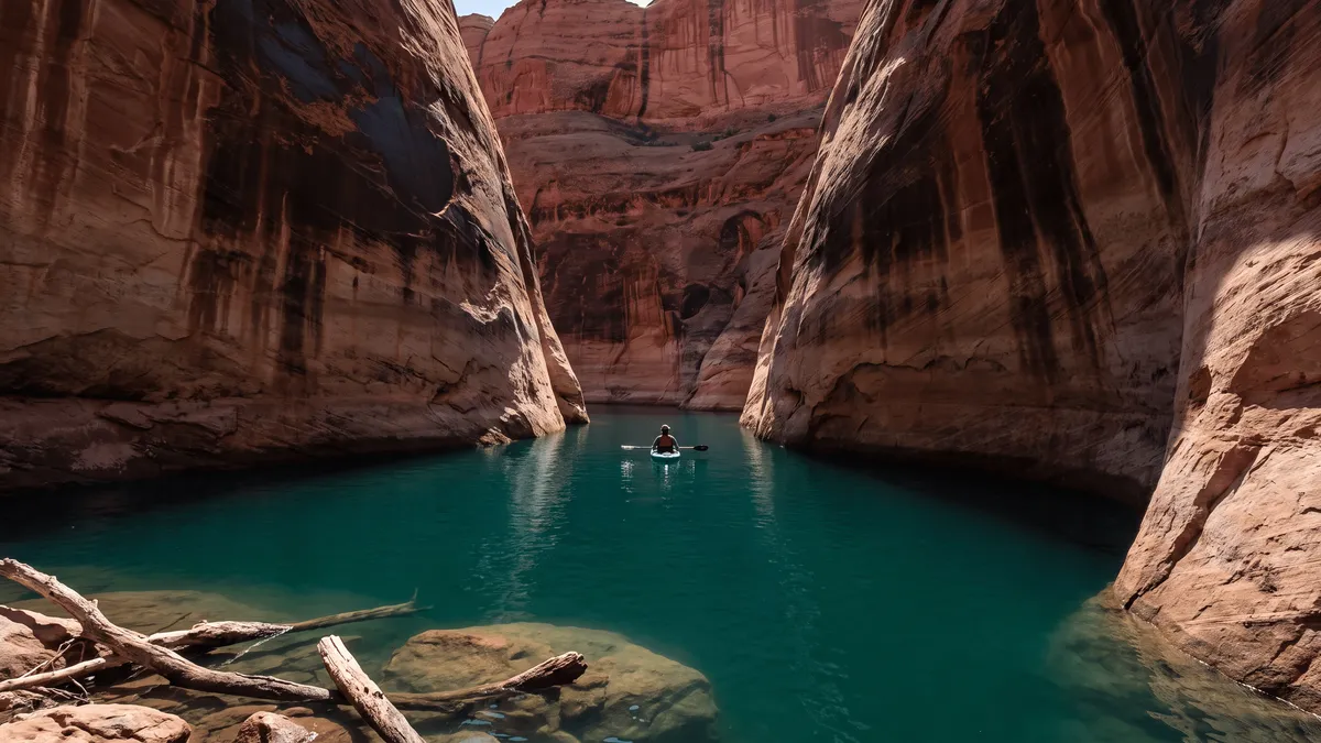
A slot canyon here is a canyon the reservoir got halfway into. The lower end is flooded and you float it; the upper end is dry and you walk it, sometimes in sand, sometimes in water to your waist. Where the two meet shifts season to season, so treat every distance below as approximate.
| Canyon | Where it is | Nearest launch | How you finish it |
|---|---|---|---|
| Labyrinth | First canyon on the right where the narrows open into Padre Bay | Wahweap / Antelope Point | Kayak or paddleboard, then ~1 mile on foot |
| Antelope (lake arm) | ~4 miles up from Glen Canyon Dam, east side of Antelope Island | Antelope Point | ~2.5-mile paddle, then a walk up the wash |
| Face | South lake, roughly 2.5 hours by houseboat from Wahweap | Wahweap | Powerboat, PWC or kayak; high shaded walls |
| West | ~25 miles uplake from Glen Canyon Dam | Wahweap | Boat the flooded part, then wade and scramble |
| Anasazi | Between buoys 52 and 53, Oak Bay to the San Juan mouth | No marina close | Small craft through the maze, then a hike |
| Cathedral in the Desert | Up Clear Creek, Escalante arm, ~23 miles south of Bullfrog | Bullfrog | Short walk up ledges into the chamber |
Which canyons does the Park Service treat as too narrow to boat?
Four of them, by name. The Glen Canyon Superintendent’s Compendium prohibits operating over 5 mph or creating a wake in Antelope, Labyrinth, Forbidding and Lost Eden Canyons, and gives the reason plainly: “The canyons are too narrow to safely allow motorized vessels to travel on plane or faster than wakeless without causing safety issues with the non-motorized watercraft.” Those four names tell you which mouths you idle through, and which ones fill up with kayakers you can’t see around a bend.
The wake rules that apply everywhere else still apply inside a canyon. The Park Service boating page says not to create a wake within 100 feet of another vessel, a swimmer, a person floating, or a designated launch site — and in water narrow enough to touch both walls, that radius covers the whole canyon. Slow down as the walls close in, put a lookout on the bow, and accept that the last stretch belongs to paddlers.
Can you kayak to Antelope Canyon, and is it the slot from the photographs?
No. Two different places share the name, and the mix-up sends people to the wrong side of Page. The flooded Antelope Canyon arm starts about 4 miles up from Glen Canyon Dam on the east side of Antelope Island, per Lake Powell Resorts & Marinas, and it’s roughly a 2.5-mile paddle from the Antelope Point launch to where the water ends on a sand beach. Upper and Lower Antelope Canyon — the orange corkscrew walls from the Arizona posters — are units of the Lake Powell Navajo Tribal Park, reached by road. The National Park Service puts it flatly: “Antelope Slot Canyon is operated by the Navajo Tribal Parks and Recreation Department and is on land owned by the Navajo Nation,” and your America the Beautiful pass does nothing there. Navajo Nation Parks & Recreation charges $15 per person to enter and states that tour guides are mandatory in Antelope Canyon.
The paddle earns a morning on its own merits. As of mid-2026, Antelope Point Marina rents singles from $11 an hour and doubles from $17 with a two-hour minimum, or $50 and $61 for a full day on a $100 deposit; boats go out at 8am and come back by 4pm, and the last rental goes at 1:30pm. Start early — the arm faces the main channel and afternoon wind makes the return paddle the hard half. The marina notes that kayaks are currently the only craft reaching the very end of the canyon.
Where the water quits, the dry wash keeps going, and plenty of paddlers walk up it. Know that you’re heading toward Navajo Nation land as you go, where the tribal park’s entry fees and guide rules take over. If the guided slot is what you came for, book it from Page and treat the paddle as a separate morning.
What is Labyrinth Canyon like?
Labyrinth is the one to do first. It’s the first canyon on the right where the narrows open into Padre Bay, an easy run from either south marina, and it winds south into a slot that ends on a small sand beach. A Wayne’s Words trip report describes the walking part well: “The bottom of the slot is sandy. Both sides can be touched by extending the arms,” with the floor narrowing to about the width of a foot in places, so you keep a hand on one wall for balance. Rocks wedged in the second section have to be scrambled over. That party covered maybe 2 miles one way in about 3 hours round trip and turned back with slot still ahead of them.
The best stretch is the first one. Other accounts put the slot section near a mile long with walls roughly 5 feet apart and about 30 feet of rock overhead, running through sand, shallow water and boulders until vegetation ends the fun. Big boats stop where the canyon tightens and anchor; the slot itself is kayak, paddleboard and wading territory. It’s a half-day out of a lake trip, and it’s the cleanest introduction to what a Lake Powell slot feels like from a kayak seat.
Which slots are worth a longer run?
Past Padre Bay the trips get more committing, and the payoff shifts from scenery to solitude. Face Canyon is the quiet one — Lake Powell Resorts describes it as offering “more shade in summer—and less traffic, so you’ll feel as though you have it all to yourself,” about 2.5 hours from the marina by houseboat and open to powerboats, PWCs and kayaks alike. It isn’t on the Park Service’s wakeless list, so the standard 100-foot rule is what governs you in there.
West Canyon, about 25 miles uplake from Glen Canyon Dam and best reached from Wahweap, is the one that turns into real work. Lake Powell Resorts calls it a slot canyon where “the slot soon narrows and a stream spreads across its floor,” with scrambling up waterfalls and stretches you wade or swim. Trip reports going back two decades count a long series of short waterfalls, some with fixed ropes left in place, and a technical upper section that needs rappels. The lower canyon is fine without gear. Low water has stretched the muddy walk between the boat and the good part, so budget more daylight than the mileage suggests.
Anasazi Canyon sits between buoys 52 and 53, between Oak Bay and the mouth of the San Juan arm. A sandstone slab splits its entrance, small boats handle the maze better than houseboats, and the hike from the beach leads to a double arch with a waterfall and plunge pool. Flash floods rearrange the streambed there season to season, so the walking varies from sand to rock without notice.
Cathedral in the Desert, up Clear Creek in the Escalante arm about 23 miles south of Bullfrog, is a chamber rather than a through-slot — Lake Powell Resorts measures the canyon at “only 12 feet wide in some places,” with a short walk up and over ledges into the room and a 60-foot waterfall at the back when it’s running. How much of that you float and how much you walk depends on where the lake sits; check the current elevation at lakepowellwaterlevel.com before you plan a day around it. For the full set of side canyons, including the ones that aren’t slots, start with our Lake Powell canyons guide.
What are the rules, and what’s the flash flood risk?
The flood risk is the rule that matters. On August 12, 1997, eleven hikers died in Lower Antelope Canyon when a storm sent a wall of water through the narrows; the archived Park Service morning report describes them as “caught by a sudden flash flood which funneled a wall of water through the very narrow canyon,” and contemporary reporting placed some of the recoveries in the shallow water where the canyon meets Lake Powell. That’s the same drainage boaters paddle up. Park Service guidance on the Glen Canyon safety page leaves no room to negotiate: “If storms or flash floods are predicted in your area, even if you do not see storm clouds or feel rain, STAY OUT OF NARROW CANYONS.” Monsoon storms build from roughly July into September, and a blue sky overhead says nothing about what’s falling upstream. Our weather safety guide has the storm and wind rules for the rest of the lake.
Day hiking in most of Glen Canyon needs no permit; the Escalante District requires one for overnight stays, and the Park Service asks you to sign the trail register either way. Before a paddle, the safety page suggests filling out a free backcountry permit “so the rangers know you are out there” — worth 5 minutes in a canyon with no signal.
The last rule is about what’s in the alcoves. The compendium flags alcoves and overhangs as archaeological or paleontological sites “even if not obvious to the casual observer,” and pedestrian traffic inside archaeological sites is restricted to constructed trails, with deviating off them prohibited. Photograph what you find from the trail and leave the rest alone.
What the run looks like from the boat
One canyon mouth looks much like the next from the main channel, and the marked water ends the moment you turn in — the numbered buoys stop at the entrance, and cell service goes with them. Mark the mouth and your anchoring spot before you leave the channel, and record the track in so you have a line to follow out. Our guide to GPS and cell service covers why your position keeps working when the map won’t load, and the Antelope Point Marina page has the launch detail for the two most-paddled slots. Pairing a slot with the long run up-lake? The Rainbow Bridge guide covers that day.
Key takeaways
- The Park Service names four canyons as too narrow to run on plane — Antelope, Labyrinth, Forbidding and Lost Eden — and those are the ones you idle into.
- Labyrinth off Padre Bay is the best first slot: sandy walking, walls you can touch on both sides, about 3 hours round trip on foot.
- The Antelope Canyon you paddle to and the Antelope Canyon you photograph are different places — the famous slots sit on Navajo Nation land, where entry runs $15 per person and a guide is mandatory.
- West Canyon holds waterfalls and stretches you wade or swim, and its upper end goes technical; Anasazi and Cathedral in the Desert are the far, quiet options.
- Check the forecast before you walk into any of them. Eleven people died in a flash flood in this drainage in 1997, and the Park Service says stay out of narrow canyons when storms are predicted anywhere nearby.
Frequently asked questions
Which slot canyons at Lake Powell can you reach by boat?
Labyrinth Canyon off Padre Bay is the classic, and the Antelope Canyon arm above Antelope Point is the most paddled. Past those: Face Canyon on the south lake, West Canyon about 25 miles uplake from Glen Canyon Dam, Anasazi Canyon between buoys 52 and 53 near the San Juan arm, and Cathedral in the Desert up Clear Creek in the Escalante. All of them start as flooded water you float and finish on foot, in sand at Labyrinth and in wading depth at West Canyon.
Can you kayak to Antelope Canyon from Lake Powell?
You can paddle the flooded Antelope Canyon arm — about 2.5 miles each way from the Antelope Point launch to where the water ends on a sand beach. The Antelope Canyon from the photographs is a separate place reached by road. Upper and Lower Antelope Canyon are units of the Lake Powell Navajo Tribal Park, where Navajo Nation Parks & Recreation charges $15 per person to enter and says tour guides are mandatory. The paddle and the guided slot are two different places in the same drainage.
Do you need a permit to hike into a Lake Powell slot canyon?
Not for day hiking in most of Glen Canyon National Recreation Area. Backcountry permits are required for overnight stays in the Escalante District, and the Park Service asks day hikers to sign the trail register. The Park Service also suggests filling out a free backcountry permit before you paddle so rangers know you are out there. Canyons on Navajo Nation land are the exception — those run on Navajo Nation Parks fees and permits and, at Antelope Canyon, a mandatory guide.
How narrow is Labyrinth Canyon?
Narrow enough to touch both walls with your arms out. Trip reports describe a sandy bottom only about the width of a foot in places, walls that close to roughly 5 feet apart through the slot section, and a rock floor about 30 feet below the rim. The slot runs somewhere around a mile before vegetation and boulders slow most people down. The prettiest stretch is the first part, closest to where the lake ends.
Can you take a houseboat into a slot canyon at Lake Powell?
Into the wide flooded mouth, yes. Into the slot, no. The Superintendent’s Compendium bans operating over 5 mph or throwing a wake in Antelope, Labyrinth, Forbidding and Lost Eden Canyons because they are too narrow for motorized boats to run on plane alongside kayaks. The practical method is to anchor a big boat where the canyon is still wide enough to turn around, then finish in a kayak, on a paddleboard, or on foot.
Are Lake Powell slot canyons dangerous?
The flash-flood risk is real and it has killed people in this drainage. On August 12, 1997, eleven hikers died in Lower Antelope Canyon when a flood funneled a wall of water through the narrows, and bodies were recovered near where the canyon meets Lake Powell. The Park Service rule is blunt: if storms or flash floods are predicted, even with clear sky overhead, stay out of narrow canyons. Check the forecast before you walk into one.
Which Lake Powell slot canyon is best for a first-timer?
Labyrinth Canyon. It is an easy run from Wahweap or Antelope Point into Padre Bay, the slot starts within a few minutes of where you beach the boat, and the walking is mostly sand with a few wedged rocks to scramble over. Nothing about it requires ropes or route-finding, and you can turn around whenever you have had enough. Budget about three hours round trip on foot if you want to walk the good part and back.
Mark the canyon mouth before you lose signal
The Navigator app names all 132 side canyons with offline waypoints and track recording, so you can find a slot’s mouth from the channel and retrace your way out once the walls cut your signal.